Nice Weather to End June
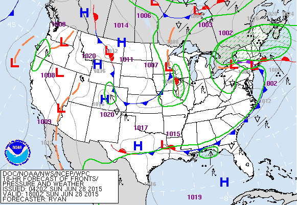
Fronts have a hard time of bringing an air mass change to the Southeast US during the summer months, but we are in the process of one now as the upper air pattern sees the establishment of a trough over the eastern US for several days. The trough and the passage of the cold front will bring some nice weather conditions to Central Alabama for June with drier air as we see dew points drop toward the 60 degree mark. With lots of sunshine as the clouds clear out we should see our afternoon highs reach the middle 80s today – a nice change from the 90s we saw last week.
At the beach, today will see more showers and storms. Storms become fewer in number for the week ahead, but they will remain in the forecast as the front stalls along the Gulf Coast. You can expect 6 to 8 hours of sun daily. Highs on the immediate coast will be in the mid to upper 80s, with lower 90s possible inland. The sea water temperature at Perdido Pass at Orange Beach was reported as 86 degrees.
Northwesterly flow presents its own set of challenges. While the upper trough will be the prevailing feature in our pattern for much of the week ahead, embedded short waves in the flow will bring thunderstorms into the Ohio River Valley. It still looks like Monday will remain dry, but we’ll have to be vigilant on developments well to our northwest as we monitor that northwest flow. With the trough, the heat is at least temporarily abated.
But the trough pattern begins to wane as we head into the middle and latter part of the week as moisture begins to come back putting the need to mention showers again in the forecast for Tuesday and through much of the week ahead. But even as the trough weakens, temperatures will remain close to seasonal values with highs in the upper 80s and lower 90s, near our 30-year averages for late June and early July.
SPC has outlined a marginal area for severe storms Monday in the Ohio Valley with the area just reaching extreme North Alabama, where the threat is higher. For now it looks like the threat will stay north of Central Alabama, but we’ll have to watch how conditions evolve to our north.
And the tropical Atlantic remained quiet this morning with no tropical storm development expected for the next several days.
By next Sunday, the upper ridge begins to develop once again to our west, so I expect to see the heat return with highs into the lower 90s. It is the ridge that become the prevailing feature as we head into voodoo country. But the GFS is once again showing the ridge pushing back to the west with more of a trough in the East as we get into the middle days of July. There’s also a hint at some action in the tropics, but we know how these features come and go this far out.
James Spann will have the next edition of the Weather Xtreme Video on Monday morning. Check back here often for weather updates.
-Brian-
Category: Alabama's Weather


