Saturday Showers and Storms
UPDATE 3:25
A new storm formed over Vestavia and has moved south to near I-459 with very loud thunder and torrential rains. My house picked up .67 inches in ten minutes. That is impressive!
The NWS has issued a significant weather advisory for southern Jefferson and northern Shelby Counties.
ORIGINAL POST
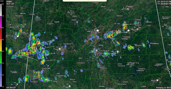
Showers and storms have formed this afternoon across North Central Alabama generally in the I-20 Corridor. Just before 3 p.m., the biggest storms were south of Moody in northeastern Shelby County and entering Pickens County from Mississippi.
The storm near Sterrett in NE Shelby County might even spit out a little teeny tiny hail.
All of them have the potential for brief heavy rain, gusty winds and lots of lightning, but they should not produce severe weather.
Everything was pushing east quickly at about 35-40 mph.
The activity is at the tail end of a long feeder band from Tropical Depression Bill, which is entering West Virginia.
SUMMER ARRIVES: The summer solstice occurs tomorrow at 11:36 a.m. The summer we have been talking about since June 1 (beginning of meteorological summer) and experiencing for weeks will finally officially be here.
Category: Alabama's Weather


