Another Toasty Day
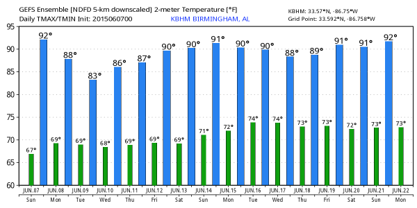
Many places across Central Alabama reached 90 degrees for highs with some spots a tad warmer as the upper ridge built into the Lower Mississippi River Valley. The high at Birmingham was 90 while Tuscaloosa recorded a high of 92. The upper ridge will gradually be dampened today and into Monday as a strong upper trough moves across the Great Lakes area. This means another warm day in store for Central Alabama with highs in the lower 90s. But as the ridge dampens over the next several days, temperatures should come back to more typical values for early June with highs in the mid and upper 80s. Showers will be hard to find again today as we saw yesterday, but can’t rule out an isolated shower in the heat of the afternoon.
As the trough moves across the Great Lakes, it will bring a front down into the Ohio and Tennessee River valleys on Monday and Tuesday. The front will have the biggest impact for Central Alabama on Tuesday, so I think that is the day with the most numerous showers and thunderstorms. SPC places much of the area along the front in a marginal risk for severe storms on Tuesday.
For beach goers, great weather continues along the Northern Gulf Coast. You will see plenty of sun today and into next week with just a passing shower to deal with from time to time. Temperatures along the coast will be in the mid and upper 80s for highs while lows will be warm with values in the middle 70s. Water temperature this morning at the Dauphin Island Sea Lab was reported to be 83.3 degrees.
In the tropics, the Atlantic Basin remains quiet with no development over the next few days. In the eastern Pacific, Hurricane Blanca was tracking north and will make landfall along the southwestern Baja Coast later tonight or early Monday, but will be weakening at the time as she will be tracking over cooler waters. Winds are currently 115 mph.
The front is expected to wash out in Central Alabama on Wednesday and Thursday, so we will need to continue to mention the possibility of afternoon and evening showers and thunderstorms. The model run this morning locates the upper ridge building back into the Southeast US more over Georgia, so we’ll have to keep an eye on the southerly flow that develops across the western Gulf of Mexico for any kind of development. The ridge will also help to see temperatures climb back into the 88 to 92 range for later in the week and into next weekend.
After being fairly consistent from model run to model run, the GFS has backed off on the development of a low pressure system in the western Gulf around June 15th. Always wary when the model makes a dramatic change like this and wonder if it could be back on the next run. For now, just have to watch and see.
James Spann will have the next edition of the Weather Xtreme Video on Monday morning. Be aware of the heat and don’t overdo it. Have a great day and Godspeed.
-Brian-
Category: Alabama's Weather


