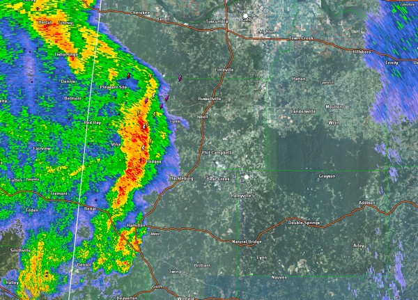
Possible Tornado/117 mph Wind Gust in Amory MS Earlier?
LATE REPORT
From the NWS Memphis: Smithville [Monroe Co, MS] public reports TORNADO at 09:03 AM CDT — smithville marina reports boats toppled over and buildings demolished. definite path of destruction.
ORIGINAL POST
That impressive little mesoscale convective vortex over Northeast Mississippi that prompted the tornado warning for the Amory and SMithville areas weakened as it moved into more stable air over Northwest Alabama and is no longer considered severe by the definition. It is still capable of strong gusty winds and is producing a fair amount of lightning and heavy rain.
It extends along an arc from Tishomingo MS to Vina in Franklin County, Alabama to near Hamilton in Marion County. It is moving northeast at about 35 mph. The strongest winds are now approaching Hamilton. It will impact the rest of Franklin and Marion Counties over the next hour.
Reports from Amory say that there is a considerable amount of damage in the downtown area from straight line winds or possibly a small tonado.
Here is a Twitter image of what may have well been a tornado in Amory. There was certainly a strong velocity couplet in the area at the time.
A home weather station in Amory reported a wind gust to 117 mph. While not official, that is still impressive.
To the south, more strong storms are north of Columbus MS and will affect northern Lamar and Marion Counties.
Further south, a severe thunderstorm warning is in effect for a small but strong cell in southwestern Noxubee County MS southwest of Macon. The warning includes Macon. This is going to affect Columbus in 90 minutes or so. It is part of an area of storms southwest of Columbus that will run into some higher instabilities as it translates eastward over the next couple of hours and pushes into West Alabama.
Category: Severe Weather


