Is This June?
Happy Mother’s Day!
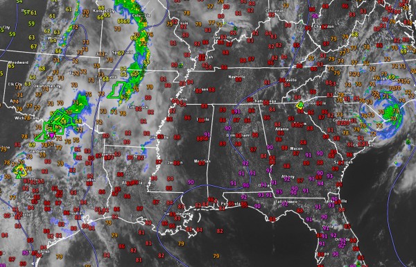
Early season warmth continues on this 2015 edition of Mother’s Day. Temperatures are near 90F in the I-20 corridor with lower 90s common over South Alabama. These readings are some 10-12 degrees above normal, feeling more like late June than early May.
To the east, the tropical depression that is the remnant of Tropical Storm Ana is pushing into North Carolina after making landfall between Myrtle Beach and North Myrtle Beach around 6 a.m.
Back here in Alabama, skies are partly cloudy with lots of cumulus clouds as moisture levels continue to slowly rise. Dewpoints are in the lower 60s for the most part, with a few middle 60s over eastern sections. Southeasterly winds are increasing the moisture.
To the west, we can see showers and storms over Texas, Oklahoma and Arkansas ahead of our western trough This is the same system that has brought days of severe weather to the Plains. Today is no exception, with a tornadic supercell crossing the northern part of the Dallas-Fort Worth metroplex. A tornado crossed the Denton area a few minutes ago and is threatening the town of Aubrey now. Fortunately, damage around Denton was relatively minor, but the storm’s circulation is tightening again as it crosses the warm front.
This activity will once again weaken tonight, as in past days. But the responsible system will begin to lift out to the northeast by tomorrow, pushing a cold front our way. This will trigger a line of showers and storms that will push southeast on Monday. Showers and storms should reach western Alabama by late afternoon but the system will be weakening with storms along the line becoming more scattered.
The SPC has areas northwest of I-59 in their standard slight risk outlook for tomorrow. Damaging winds and hail will be threat.
Category: Alabama's Weather


