Rain/Storms Move In Tonight
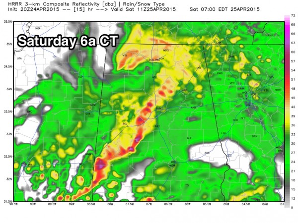
ACTIVE SETUP AS THE WEEKEND BEGINS: Clouds will thicken across Alabama over the next few hours, and rain will move into West Alabama this evening as a warm front begins to push northward. We expect a good rain/thunderstorm event overnight, with the heaviest and most widespread rain along and north of I-20. Rain amounts tonight will be in the 1/2 to 1 inch range, we will monitor the storms for severe weather potential. Higher dewpoints and unstable air will advect up into the state early tomorrow.
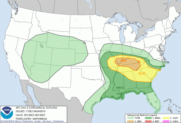
TOMORROW: SPC has adjusted their outlook tomorrow a bit; now the standard “slight” risk of severe weather is in place north of a line from Russellville to Alabaster to Opelika… a “marginal” risk south of that line. The “enhanced” risk is north of Alabama, for parts of Tennessee and Kentucky.
Surface based CAPE values will rise to near 3,000 j/kg tomorrow afternoon, the most unstable air we have seen all year. EHI (Energy Helicity Index) values peak at over 3 units over Northeast Alabama tomorrow afternoon. Wind fields and shear values are not overwhelming, but they are certainly supportive of the potential for a few severe thunderstorms.
Here are the important things to know about tomorrow…
*I can’t rule out a few early morning severe storms as the big rain mass moves out of Alabama… in the 4:00 to 7:00 a.m. time frame. Main risk will be from hail and gusty winds, although an isolated tornado is not completely out of the question.
*Rain and storms will end from west to east early tomorrow morning, and most of the rain should be in Georgia by 9:00 a.m.
*The middle of the day, and a decent part of the afternoon will be dry, with some sun at times. Temperatures will rise into the low 80s.
*Scattered storms will form tomorrow afternoon and early tomorrow night, and where those storms develop they could be severe. Understand, not everyone will have a thunderstorm tomorrow evening, but where they form they could become severe quickly.
*The main window for scattered severe storms will come from about 3:00 p.m. until 9:00 p.m., and the better chance of them will be along and east of I-65, where dynamic support will be higher.
*The risk of severe weather over the southern half of the state is fairly low.
Everyone should have a way of receiving severe weather watches and warnings if they are needed.
BIRMINGHAM NOAA WEATHER RADIO: The Birmingham system remains down; the NWS is working as hard as they can to get service restored, but if you are in the Birmingham metro, understand you won’t get warnings via Weather Radio until the transmitter is back. A good alternative is a smart phone app like WeatherRadio by WDT, or MyWarn.
SUNDAY: SPC has a “marginal” severe weather threat for the southern part of Alabama, south of a surface boundary… we believe the northern half of the state will be dry with a partly sunny sky and a high around 80 degrees.
NEXT WEEK: Monday will stay dry; rain returns Tuesday afternoon through Wednesday, but this system won’t bring a severe weather threat since a relatively weak surface low will pass south of us, near the Gulf Coast. For now it looks like a harmless spring rain event. Drier air returns Thursday and Friday. See the Weather Xtreme video for maps, graphics, and more details.
WEATHER BRAINS: Don’t forget you can listen to our weekly 90 minute netcast anytime on the web, or on iTunes. This is the show all about weather featuring many familiar voices, including our meteorologists here at ABC 33/40.
CONNECT: You can find me on all of the major social networks…
Facebook
Twitter
Google Plus
Instagram
I had a great time today visiting with the kids at Sulligent Elementary School in Lamar County… be looking for them on the Pepsi KIDCAM today at 5:00 on ABC 33/40 News! My next Weather Xtreme video will be posted here by 7:00 a.m. Monday… Brian Peters will have the video updates tomorrow and Sunday. And, we will post frequent updates on the Alabama weather situation over the next 24 hours, so stay tuned…
Category: Alabama's Weather


