Some Rain Possible This Afternoon
RADAR CHECK: Models have not done a good job handling the precipitation fields today; despite a surface front in the area, the radar is quiet this morning, and there is no rain in progress statewide. However, west of the state, there is a rather large mass of rain and thunderstorms over parts of Arkansas and Louisiana thanks to a wave embedded in the sub-tropical jet stream, and that wave is moving east. This means it now looks like the best chance of rain today will actually during during the afternoon hours (models had suggested the showers today would be this morning).
So… we will adjust the forecast accordingly and mention rain this afternoon, generally in the 12:00 noon to 6:00 p.m. time frame. There could be some thunder, but there is no significant risk of severe weather, and rain amounts should be under 1/2 inch. Best chance of rain will be south of a line from Vernon to Warrior to Alexandria… rain seems unlikely north of U.S. 278 (Hamilton to Cullman to Gadsden) where the air will be drier.
TOMORROW: Most of the day will be dry; some sun at times with a high in the mid 70s. An afternoon shower can’t be ruled out, but most of the rain will hold off until tomorrow night. High resolution NAM model output hints the rain begins sometime between 6:00 and 9:00 tomorrow night as a warm front lifts northward, and we will have periods of rain and thunderstorms through the night. The severe weather risk is fairly low tomorrow night, although a few stronger storms are certainly possible.
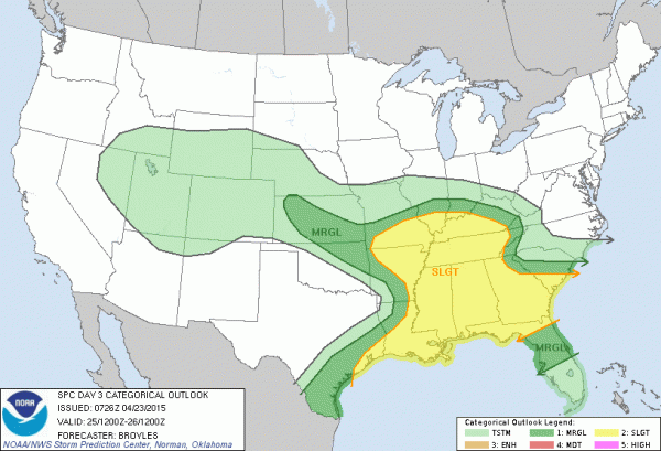
SATURDAY: The Storm Prediction Center has all 67 Alabama counties in the standard “slight” risk of severe weather…
Here are some thoughts about Saturday’s weather…
*It won’t rain all day, and the sun could break out at times. The high res NAM suggests we could see storms early in the day, followed by a midday break in the rain, then more storms by late afternoon and into Saturday night.
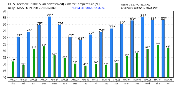
*It will be a warm day, with a high at or just over 80 degrees. This will help to make the air unstable; surface based CAPE values are expected to exceed 2,000 j/kg by afternoon.
*Forecast parameters suggest all modes of severe weather will be possible, including hail, strong straight line winds, and a few isolated tornadoes.
*It is impossible to give you start/stop times for rain at any specific location… just understand where storms develop, they could be strong to severe.
There are many, many outdoor events going on, so just be sure you have a way of hearing watches and warnings.
SUNDAY/MONDAY: These two days looks dry and pleasant with highs in the 78-82 degree range. Eyes will be on another dynamic weather system off to the west, impacting Texas and some of the adjacent states.
TUESDAY/WEDNESDAY: That Texas system will impact Alabama on these days, but we have more questions than answers now. Both the GFS and the ECMWF have been trending southward with the surface low, and this would reduce any risk of severe weather for the northern two-thirds of Alabama, meaning the main issue here would be from heavy rain. We really need to get past the Saturday system to feel confident about telling you what will happen with this one. See the Weather Xtreme video for maps, graphics, and more details.
WEATHER BRAINS: Don’t forget you can listen to our weekly 90 minute netcast anytime on the web, or on iTunes. This is the show all about weather featuring many familiar voices, including our meteorologists here at ABC 33/40.
CONNECT: You can find me on all of the major social networks…
Facebook
Twitter
Google Plus
Instagram
I have a weather program this morning in northern Etowah County at Whitesboro Elementary School… be looking for the next Weather Xtreme video here by 4:00 this afternoon. Enjoy the day!
Category: Alabama's Weather


