Round 1 Ending For Central Alabama. Two Rounds to Go.
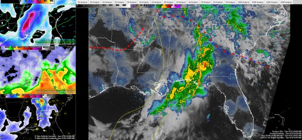
Active weather continues across Southeast Alabama this morning as severe thunderstorms associated with an upper level disturbance move into Georgia. A strong upper level jet helped to intensify the storms and low level spin in the atmosphere allowed possible tornadoes to spin up.
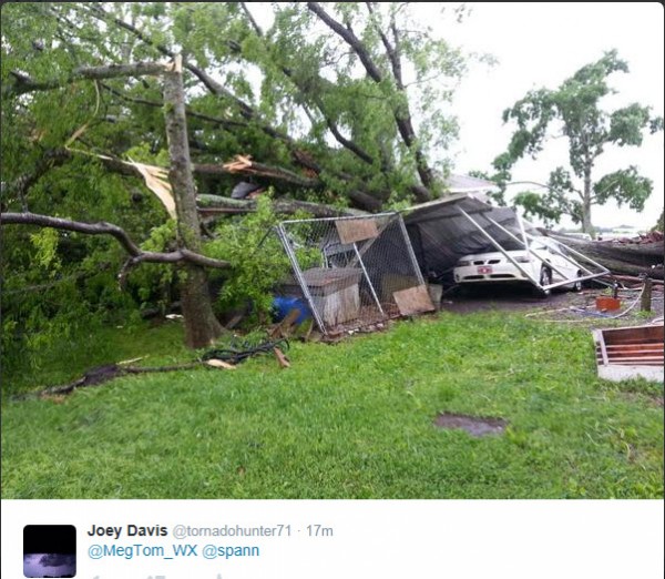
Wind damage was reported in Leesburg, especially along AL-68 and Keener Driver, with numerous trees down, including one on a house. Injuries were reported. There are a few tweets that it was a tornado, which is possible, but the radar signatures looked more like straight line winds. Doesn’t rule out that it was a tornado, but the damage from strong straight line winds can be as bad as those of a tornado. NWS survey teams will investigate.
Here is an example of the damage at Leesburg:
Further south, there were strong radar indications of a tornado moving across Russell County earlier. There was actually a tornadic debris signature on Doppler Radar for a time. Structural damage was reported just southeast of Fort Mitchell in Russell County.
That storm is in Georgia near Fort Benning now and is again producing a debris signature. The NWS Atlanta notes the debris is as high as 7,000 feet, indicating a significant tornado.
A tornado watch continues for for much of Georgia, Northwest Florida and East/Southeast Alabama, but the threat is over for areas behind the line of storms.
ROUND TWO
The system responsible for our severe weather is a weakening upper level low over the Central Plains. The low is opening up into a strong trough over Kansas and northern Oklahoma this morning. Disturbance one, which caused the morning round of rain/storms is lifting into eastern Tennessee. The next upstream disturbance is crossing the Mississippi River. It will affect Alabama this afternoon. Will the atmosphere be able to recover from the morning rain and storms?
Skies have cleared over Mississippi with drier air moving in behind the first disturbance. This clearing is moving into western Alabama as well. Temperatures will warm into the upper 70s to near 80F this afternoon. This will allow instabilities to increase to over 2,000 j/kg by early afternoon. Scattered thunderstorms should develop in areas mainly along and south of I-59 by 2-3 p.m. or so. Bulk shear will still be running 30-50 knots along and south of I-59, so storms will be able to organize. There will still be over 100 m2/s2 of low level helicity at that time, so we will be watching for the threat of tornadoes as well.
So, severe weather will probably not be widespread with the afternoon round, but there could be a handful of discrete storms that could produce damaging winds, hail and even a couple of tornadoes, mainly along and south of I-59. But everyone needs to remain weather aware through the afternoon.
ROUND THREE
Another event will come into the state overnight as the main axis of the upper level trough affects Alabama. Storms will fire over Arkansas and northern Louisiana by late afternoon and move across Mississippi during the evening. These storms will be crossing into Alabama before midnight. Now the good news is that they should be weakening. But there should be enough instability ahead of the storms to produce additional severe weather during the late night hours. Decent bulk shear means the storms will be organized and hence strong. Strong low level helicities of 125-200 m2/s2 means that a couple of isolated tornadoes are possible as well.
NEW WORK WEEK
Weather should rapidly improve on Monday as a cold front sweeps through the area. Winds will be brisk, out of the west and northwest tomorrow, and dewpoints will be crashing, making it feel chillier despite increasing sunshine from clearing skies. Highs on Monday afternoon will be in the lower and middle 70s. Monday night lows will be in the 40s and lower 50s. Tuesday and most of Wednesday look to be dry before a passing disturbance brings showers back into the forecast as early as late Wednesday, more likely on Thursday.
WEEKEND SNEAK PEEK
Next weekend looks like it will be wet, with heavy rain returning as early as Friday night. Saturday looks very wet.
Category: Alabama's Weather, Severe Weather


