Occasional Showers/Thunderstorms
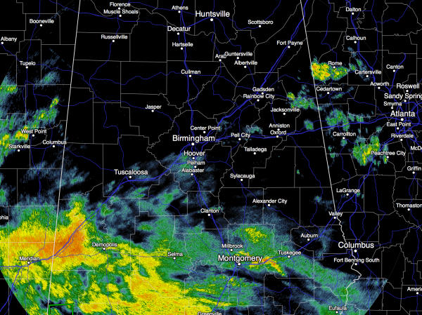
SOGGY PATTERN CONTINUES: At daybreak rain is falling across parts of Central and South Alabama, and that rain is moving northward. Temperatures are in the 57-61 degree range in most places… it is cooler over East Alabama in the wake of the wedge front that moved in from the east yesterday.
It won’t rain all day today, and rain amounts will be lighter than yesterday for most, but no doubt it will rain at times with a cloudy sky. The high today will be in the 60s over the eastern half of the state, with 70s for West Alabama. Some thunder is possible, but there is no risk of severe weather for the northern counties.
WEEKEND FORECAST: Computer models are clearly struggling with the small scale details of this wet pattern; they have been all over the board making it a challenge to call the specific start/stop times of the rain over the weekend.
The latest batch of guidance for tomorrow is more encouraging for those of you trying to do something outdoors. Clearly, a shower is possible at any time, but it won’t rain all day, and the organized mass of rain and storms could hold off until late in the day and tomorrow night.
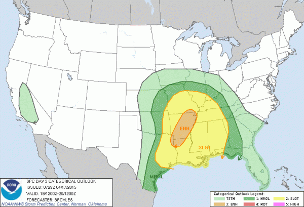
Seems the most widespread rain over the weekend will come tomorrow night into Sunday… interesting to note that the guys at SPC have put much of our state in the standard “slight” risk of severe weather Sunday.
With the big upper trough lifting out from the western U.S., dynamic support will increase for stronger storms, but for now it seems like surface based instability will be pretty limited, and shear values are not high at all. Some of the storms in Alabama Sunday could produce hail and strong, gusty winds; we will keep a close eye on parameters to see if anything changes. Seems like the overall tornado threat is low Sunday, but not zero. The high Sunday will be in the 75-80 degree range.
SPRING FOOTBALL: Annual “A Day” games are set tomorrow in Tuscaloosa (2:00p CT kickoff at Bryant-Denny Stadium) and Auburn (1:00p CT kickoff at Jordan-Hare Stadium). The news is a little better this morning with guidance holding off the most widespread rain until late in the day. A decent chance the game at Auburn will be played with generally dry conditions, although a passing shower is certainly possible. The chance of rain at Tuscaloosa will be higher, but I don’t think it rains for the entire game. One way or another I would take the rain gear at both stadiums. Temperatures will be in the low to mid 70s tomorrow afternoon.
NEXT WEEK: A few stray showers are possible Monday as the upper trough passes overhead, but we will finally enjoy two dry, sunny days Tuesday and Wednesday with lower humidity and cooler nights. Moisture returns late in the week with showers and storms possible late Thursday and Friday; the latest GFS runs suggest severe potential will be low, but it is too early to call. See the Weather Xtreme video for maps, graphics, and more details.
AT THE BEACH: Mostly cloudy conditions continue from Panama City to Gulf Shores through Sunday with occasional showers and thunderstorms, just a small risk of a shower Monday, followed by mostly sunny weather Tuesday and Wednesday of next week. Highs will stay in the 70s… and sea water temperatures are mostly in the low to mid 70s.
WEATHER BRAINS: Don’t forget you can listen to our weekly 90 minute netcast anytime on the web, or on iTunes. This is the show all about weather featuring many familiar voices, including our meteorologists here at ABC 33/40.
CONNECT: You can find me on all of the major social networks…
Facebook
Twitter
Google Plus
Instagram
I will be doing a weather program this morning at Pinson Elementary… look for the next Weather Xtreme video here by 4:00 this afternoon. Enjoy the day!
Category: Alabama's Weather


