Late Morning Notes
After a review of the new 12Z model data… here is an update on what to expect tonight and tomorrow…
*The severe weather risk for tonight remains very small; severe thunderstorms are not expected along the Arctic front.
*The bulk of the precipitation with this event will be in the form of freezing rain and sleet. There could be some light snow as it all winds down.
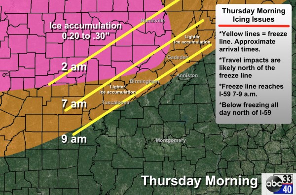
*The most significant freezing rain/sleet will come where a winter storm watch is in effect; over North and Northwest Alabama. Up to 0.30″ of ice accumulation is possible for places like Hamilton, Guin, Haleyville, Cullman, Jasper, Fayette, and Sulligent.
*Lighter ice amounts are expected for Birmingham, Gadsden, and possibly Tuscaloosa (it could be just a cold rain at Tuscaloosa with the temperature holding at 33-34 degrees). But, it doesn’t take much ice for bridges and overpasses to become icy and dangerous.
*There is a decent chance Anniston does not drop below the mid 30s with just a cold rain there. Not a guarantee, however… it is a very close call, and this could change easily.
*There is still a good bit of model conflict between the NAM and the GFS concerning the timing of the freeze line on the journey south. We will lean toward the faster and colder GFS model on the graphic below, but confidence is not especially high.
Remember, models usually don’t handle shallow layers of cold air very well, and this is the most challenging part of the forecast. Timing and placement of the 32 degree (F) line. This forecast can, and probably will change later today or night.
*Winter storm warnings will be issued later today for parts of North Alabama; those will come from NWS offices in Birmingham and Huntsville, and should be very similar to their existing winter storm watches.
Stay tuned for updates later in the day…
Category: Alabama's Weather


