Historic Snow Storm
A historic snow storm continues to impact North Alabama late this afternoon with impacts being felt as far south as Tuscaloosa, Birmingham and Anniston.
Snow will accumulate as far south as a line from Eutaw to Centreville to Calera to Sylacauga to Roanoke.
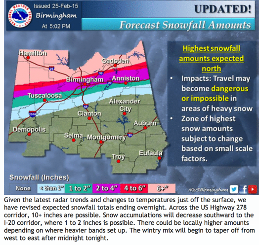
Here is the NWS Birmingham’s updated snowfall forecast:
Snow is now falling in Tuscaloosa according to John Oldshue and and Reform in Pickens County.
Snow is now falling in western Jefferson County at the Miller Steam Plant.
Traffic is a nightmare tonight in the areas that have seen snow. Corridor X (I-22) is impassable at Exit 26. ALDOT reports that I-65 is closed due to stuck traffic NB at MM 298 and SB at MM 317.
The back edge of the snow is over western Mississippi. It will be midnight before the precipitation ends along I-65 and during the early morning hours over East Alabama. It is still snowing heavily at Columbus MS.
SNOW TOTALS
CULLMAN
6″ Cullman Emergency Operations Center
8″ at Good Hope
MARION
Flashes were reported in Guin, where limbs are breaking under the weight of the heavy wet snow. That is probably the fuse blowing on a power transformer. 8″ of snow at Guin. Power outages are being reported along US_278 between Hamilton and Natural Bridge.
BLOUNT
6″ at Hayden
4″ at Locust Fork
6″ at Blountsville
ETOWAH
5″ at Altoona
WINSTON
7″ at Haleyville
LAMAR COUNTY
6″ at Detroit
MARION COUNTY
9″ at Bear Creek
9″ at Hackleburg
6.5″ at Hamilton
WALKER COUNTY
6″ at Curry
MARSHALL COUNTY
6″ at Boaz
ALABAMA POWER IS READY, ARE YOU? Our friends at Alabama Power are monitoring the forecast closely, ready to deploy people and assets to quickly address any outages that might occur. Read a special message from Ike Pigott about their commitment to their customers.
Stay tuned for more updates…
Category: Alabama's Weather, Winter Weather


