Sounding Comparison
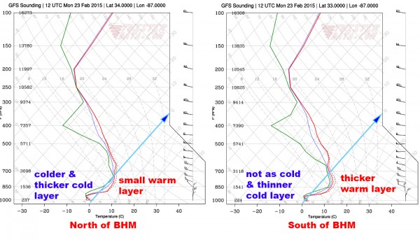
In an earlier post, I noted that the big problem with winter weather in the Southeast US is the uncertainty and how much difference small changes can make in the weather and the impact of that weather. When the latest 12Z GFS model output started coming in, I grabbed two model soundings from the model grid points that were just north and just south of Birmingham. There is no grid point right on the city unfortunately. I’ve combined the two soundings into one image below (you can click for a larger view). The blue line highlighted with a blue arrow at the end of the line runs along the freezing line.
What the model sounding shows is a freezing rain sounding north of Birmingham where the warm layer is thinner and the cold air adjacent to the ground is thick than that of the warm layer for the grid point south of Birmingham where the cold air next to the ground is thinner. But you will also note that there is some separation between the red line (temperature) and green line (dew point), so there is some room for evaporation, a cooling process, to occur in both soundings. And that’s one of the big unknowns as to whether or not the model has accounted accurately for evaporative cooling.
So when you look at these two soundings, you can see why it is a “close call” and the “close” part happens to cut right through a major metropolitan area because weather doesn’t give a flip for political boundaries.
I simply implore everyone to be safe and don’t take any chances with winter weather.
-Brian-
ALABAMA POWER IS READY, ARE YOU? Our friends at Alabama Power are monitoring the forecast closely, ready to deploy people and assets to quickly address any outages that might occur. Read a special message from Ike Piggot about their commitment to their customers.
Category: Alabama's Weather, Winter Weather


