Wintry Mix For North Alabama
An all new edition of the ABC 33/40 Weather Xtreme video is available in the player on the right sidebar of the blog. You can subscribe to the Weather Xtreme video on iTunes by clicking here.
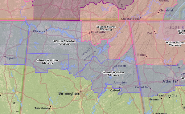
WINTER WEATHER ADVISORY: There isn’t been much overall change in our short-term forecast for the next 24 hours. The NWS in Birmingham has issued a winter weather advisory for the northern-most counties in their county warning area, as potential for a “wintry mix” continues later today and tonight.
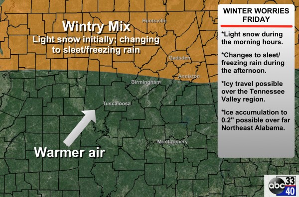
TIMING/PLACEMENT: Light snow/sleet should begin over North Alabama during the midday/early afternoon hours (11:00 a.m. until 1:00 p.m.). The highest chance of this winter precipitation will be north of a line from Vernon to Warrior to Oxford. To the south, just some scattered light rain is expected.
The cold air over Alabama is very dry now (dewpoints 5-10 degrees), and precipitation amounts this afternoon will be light. Precipitation (which will be changing to freezing rain, and then rain), will continue at times tonight.
PRECIPITATION TYPE: Initially it should be light snow, and a slow change to sleet and freezing rain as the cold air becomes shallow, and warm air advection begins aloft. And, tonight, it will slowly change to rain from the west, with the exception of Northeast Alabama, where freezing rain could continue through the night. It can be very hard to scour out the Arctic air over Northeast Alabama thanks to the CAD (cold air damming) effect, and freezing rain can linger longer than you think.
ACCUMULATION: Snow amounts will be light, generally around 1/2 to 1 inch over the Tennessee Valley. The core issue is ice accumulation over Northeast Alabama, where up to 0.25″ is possible in spots. This is why a winter storm warning is up for DeKalb, Jackson, and Madison Counties.
IMPACT: Roads and bridges could become icy over parts of North Alabama this afternoon and tonight where the “wintry precipitation” falls… highest chance of travel issues will be along and north of U.S. 278, or north of a line from Hamilton to Cullman to Gadsden. There could be enough ice accumulation over Northeast Alabama (mainly Jackson, DeKalb, and Cherokee counties) for some tree limbs to break away, resulting in some scattered power outages.
REMEMBER: As this unfolds today, the precipitation won’t exactly follow those clean lines on the maps we show… and the forecast can, and probably will change. Keep an eye on the blog today for updates. And, read the “10 things you need to know about winter weather forecasting” if you haven’t already.
TOMORROW: Freezing rain could linger over far Northeast Alabama into the early morning hours, but for most of North Alabama it will be just rain tomorrow. The good news is that it will be warmer; temperatures could reach 60 degrees in Birmingham, and parts of South Alabama could approach 70 during the afternoon. It won’t rain all day tomorrow, but occasional showers are likely, with the most numerous ones coming along and north of I-59.
TOMORROW NIGHT: A cold front will approach, and we could very well have some thunderstorms involved with a limited degree of instability. No severe weather, however.
SUNDAY: It looks like a day with temperatures going the wrong way. We start the day with low 50s around daybreak, and then we should fall slowly through the 40s with a chilly north wind. Rain remains possible, if not likely Sunday morning, but it should be light. Sunday afternoon and Sunday night are looking dry for now.
MONDAY: Yet another wave in the southern stream will bring the threat of some precipitation to Alabama. Looks like a cloudy day with temperatures in the 30s; the GFS hints the best chance of a “wintry mix” will be near, or maybe just south of the I-20 corridor during the day. It remains to be seen if this will have any impact on travel, it is simply too early to call. Just something to watch over the weekend. The latest GFS in hand (the 06Z run) suggests the main chance of wintry precipitation will come during the midday and afternoon hours.
REST OF NEXT WEEK: Another wave will bring some light rain Wednesday, and the following one could bring rain on Saturday February 28. Take some time to watch the Weather Xtreme video for maps, graphics, and more details.
ALABAMA POWER IS READY, ARE YOU? Our friends at Alabama Power are monitoring the forecast closely, ready to deploy people and assets to quickly address any outages that might occur. Read a special message from Ike Piggot about their commitment to their customers.
FIRST ALERT STORM TEAM TOUR: Our annual severe weather awareness tour across Alabama rolls along; we will be in Rockford next Tuesday evening (February 24). Just drop by anytime from 4:00 until 6:30… you can watch me do weather live on ABC 33/40, get some free stuff to take home, and have a chance to win several NOAA Weather Radios we will be giving away. If you need your weather radio programmed or checked, bring it by and we will be glad to help.
WEATHER BRAINS: Don’t forget you can listen to our weekly 90 minute netcast anytime on the web, or on iTunes. This is the show all about weather featuring many familiar voices, including our meteorologists here at ABC 33/40.
CONNECT: You can find me on all of the major social networks…
Facebook
Twitter
Google Plus
Instagram
I have a weather program this morning at Walter Kennedy Elementary School in Pell City… we will have updates throughout the day, so stay tuned…
Category: Alabama's Weather


