Arctic Air Invades Alabama
An all new edition of the ABC 33/40 Weather Xtreme video is available in the player on the right sidebar of the blog. You can subscribe to the Weather Xtreme video on iTunes by clicking here.
HARD FREEZE AHEAD: Strong north winds gusting to 40 mph at times have developed across Alabama this afternoon following an Arctic front that brought snow showers to some of the northern counties this morning. We project a low in the 10-15 degree range early tomorrow, with a wind chill index near zero. Many school systems have delayed opening due to the cold.
Tomorrow will be sunny, but very cold day with most places staying below freezing. Communities north of Birmingham won’t get out of the 20s.
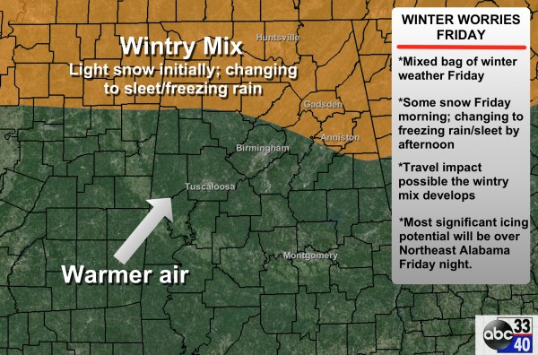
WINTER STORM POTENTIAL FRIDAY: The NWS Huntsville has issued a winter storm watch for their counties in North Alabama Friday and Friday night as another wave in the southern branch of the jet stream promises to bring a winter weather mess to parts of the Deep South.
TIMING: Wintry precipitation will begin Friday morning, and continue through the afternoon hours and into and Friday night.
PLACEMENT: The greatest impact should come north of a line from Hamilton to Curry to Remlap to Springville and to Wedowee. The most significant issues will most likely come over Northeast and East Alabama, where freezing rain could linger into early Saturday morning. Highest ice accumulation should come over Jackson, Madison, Marshall, DeKalb, Blount, Etowah, Cherokee, St. Clair, and Calhoun counties, where cold air will hang in longer.
For now it looks unlikely that there will be any significant winter weather issues for Birmingham or Tuscaloosa.
PRECIPITATION TYPE: Initially this will be all snow with this very cold Arctic air in place, but with warm air advection aloft, the cold air becomes shallow, and the precipitation will change over to sleet and freezing rain during the afternoon hours and into Friday night. By 9:00 p.m. Friday, areas west of I-65 should just be in rain with temperatures above freezing, but freezing rain will continue east of I-65 and mostly north of I-20. This is where the highest impact will most likely happen with ice accumulation.
ACCUMULATION: Snow amounts of 1-3 inches are possible over the northern third of Alabama by Friday afternoon (mostly north of U.S. 278), and ice accumulation to 0.4″ are possible over the northeast counties of the state by Saturday morning.
IMPACT: Travel will be impacted where the wintry precipitation falls, and there could be enough ice accumulation over Northeast Alabama to bring down tree limbs and cause power outages.
It will be a classic battle between the cold air damming (CAD) in place over Northeast Alabama, and the warm air advection pattern to the southwest. This forecast, can, and probably will change as we get closer to the event. So please check future blog discussions.
THE ALABAMA WEEKEND: The good news is that it will be much warmer. Some global model guidance is now suggesting a decent part of the day Saturday will be dry, but no doubt showers will remain possible. Temperatures will rise to near 60 degrees Saturday afternoon up to I-20; parts of South Alabama could reach 70 degrees.
Sunday looks wet with rain likely, and maybe even a thunderstorm or two as a cold front moves through the state.
NEXT WEEK: Cold, dry weather looks like Monday through Wednesday with highs mostly in the 40s and lows mostly in the 20s. And, evidence of more winter weather mischief toward the end of the week. Take some time and watch the Weather Xtreme video for maps, graphics, and more details.
FIRST ALERT STORM TEAM TOUR: Our annual severe weather awareness tour across Alabama rolls along; we will be in Cordova tomorrow evening. Just drop by anytime from 4:00 until 6:30… you can watch me do weather live on ABC 33/40, get some free stuff to take home, and have a chance to win several NOAA Weather Radios we will be giving away. If you need your weather radio programmed or checked, bring it by and we will be glad to help.
WEATHER BRAINS: Don’t forget you can listen to our weekly 90 minute netcast anytime on the web, or on iTunes. This is the show all about weather featuring many familiar voices, including our meteorologists here at ABC 33/40.
CONNECT: You can find me on all of the major social networks…
Facebook
Twitter
Google Plus
Instagram
I had a great time today visiting the kids at Indian Valley Elementary School in Sylacauga… be looking for them on the Pepsi KIDCAM today at 5:00 on ABC 33/40 News! The next Weather Xtreme video will be posted here by 7:00 a.m. tomorrow…
Category: Alabama's Weather


