Mid-Morning Update
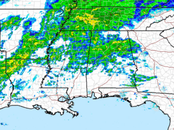
The rain continues to overspread the state this morning and for the next several hours we will see a cold rain persist. Looking at the regional radar, there is a lot of precip spreading east across the Mississippi Valley and we are in for a rather day across the state. The rain will last through the afternoon, evening, and into the overnight hours as a low pressure system tracks across the Southeast.
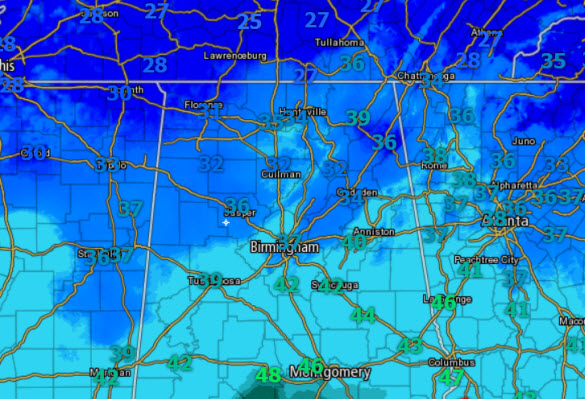
Now to the most important factor…temperatures. The 9AM temps across the area shows most of Central Alabama is above freezing, so there are no significant issues with ice or accumulations, but the farther north you head, there will be some issues. The freezing line is roughly along the U.S. 278 corridor and there are some reports of icy patches in our northern counties. Temps will be increasing slowly today, and we will be in good shape for most of today. However, where the light to moderate rain is falling, there are areas of sleet mixing in with the rain. Once again, with temps above freezing, no issues along and south of the Interstate 20 corridor.
Later this evening, as the low begins to shift east of the state, we will be watching the colder air once begin to be pulled south. With the moisture in place, we should begin to see the rain transition over to frozen precipitation, mainly over our northwestern counties. The latest model runs will be out in the next couple of hours and we will have more about this transition later today. Stay warm on this wet, raw, and cold Monday.
ALABAMA POWER IS READY, ARE YOU? Our friends at Alabama Power are monitoring the forecast closely, ready to deploy people and assets to quickly address any outages that might occur. Read a special message from Ike Piggot about their commitment to their customers.
Category: Alabama's Weather, Winter Weather


