Messy Monday; Then Much Colder
An all new edition of the ABC 33/40 Weather Xtreme video is available in the player on the right sidebar of the blog. You can subscribe to the Weather Xtreme video on iTunes by clicking here.
CHALLENGING FORECAST: I posted this on Twitter last week, and I will post it again this week. The forecast for Alabama this week remains one of these…
THIS MORNING: A winter storm warning is in effect for the northwest corner of our state; Colbert and Lauderdale Counties. A winter weather advisory is up for the rest of the Tennessee Valley.
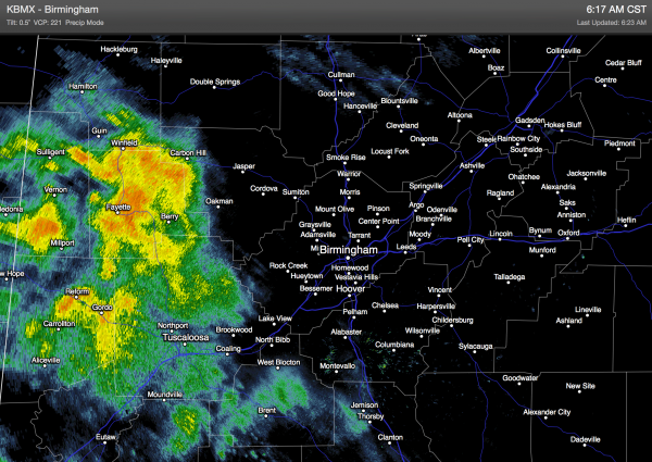
Rain is increasing over West Alabama at daybreak…
Temperatures are above freezing, and there are no ice issues in this rain mass. The only risk of icing will remain generally north of U.S. 278 this morning (Hamilton to Cullman to Gadsden), and that risk is only for a brief time. We will warm through the day as a surface low brings warmer air northward, and we could reach 50 degrees this afternoon.
With good dynamic forcing, we might even hear some thunder in spots during the afternoon/evening hours as a cold front moves through. In fact, strong storms are possible over the southern half of the state with potential for wind gusts over 40 mph. Rain amounts of around 1 inch are likely.
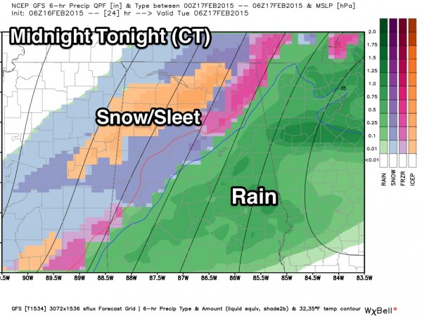
TONIGHT: As colder air moves into the state, there is a chance the rain will change over to snow or sleet before ending.
The main window for wintry precipitation tonight will come from 9:00 p.m. until 3:00 a.m. While at the moment it looks like it will be a quick hitting event with no serious accumulation, I can’t rule out some travel impact late tonight or tomorrow morning as temperatures will fall into the 20s after midnight. There are no advisories now, but we will watch radar and thermal trends closely. Keep an eye on the blog for updates later today.
TOMORROW/WEDNESDAY: We trend colder. Tomorrow will be mostly dry, but occasionally cloudy with a high only around 40 degrees. A disturbance could squeeze out a few snow flurries Wednesday, but nothing significant is expected, and again the high will be close to 40 degrees.
INTO THE DEEP FREEZE THURSDAY: The 00Z GFS is printing a low of 12 degrees, and a high of 30 degrees for Birmingham Thursday as we go into some seriously cold air. The day will be dry and mostly sunny.
FRIDAY WINTER WOES? Global models bring the next wave in here Friday with potential for more winter weather fun and games. If surface temperatures are as cold as advertised Thursday, we could see a freezing rain problem (the cold air will be shallow). The GFS is printing a high of only 32 degrees Friday with widespread freezing rain and potential significant ice accumulation. However, forecasting this kind of event five days out is extremely difficult, and much can change in coming days. Just be aware there is potential for a winter storm Friday, but things could trend warmer and it could be just another rain event like today.
THE ALABAMA WEEKEND: The weather stays unsettled, but we warm up with a high in the 40s Saturday, and 50s Sunday. We will deal with periods of rain both days, but for now ice/snow issues are not expected.
Take some time to watch the Weather Xtreme video since this is a very complex forecast over the next seven days.
FIRST ALERT STORM TEAM TOUR: Our annual severe weather awareness tour across Alabama rolls along; we will be in down Cordova Thursday evening. Just drop by anytime from 4:00 until 6:30… you can watch me do weather live on ABC 33/40, get some free stuff to take home, and have a chance to win several NOAA Weather Radios we will be giving away. If you need your weather radio programmed or checked, bring it by and we will be glad to help.
WEATHER BRAINS: Don’t forget you can listen to our weekly 90 minute netcast anytime on the web, or on iTunes. This is the show all about weather featuring many familiar voices, including our meteorologists here at ABC 33/40. We will produce this week’s episode tonight at 8:30 CT… you can watch it on “James Spann 24/7” on cable systems around the state, or on the web here.
CONNECT: You can find me on all of the major social networks…
Facebook
Twitter
Google Plus
Instagram
Stay tuned for updates on the Alabama weather situation through the day… I will have the next Weather Xtreme video here by 4:00 this afternoon. Enjoy the day!
Category: Alabama's Weather


