Late Night Check
Things are calm across Alabama at this late hour as we continue to watch developments to the west of us.
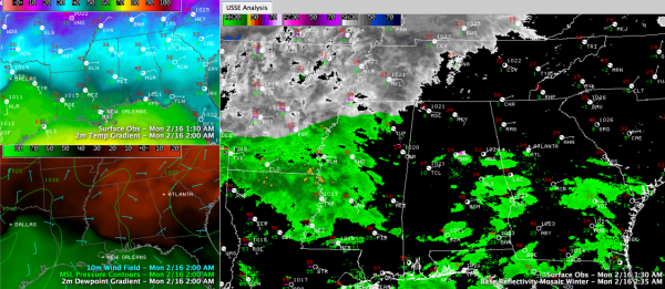
Across Central Alabama right now, we see 33F at Birmingham and Anniston with 38F at Tuscaloosa. It was 30F at Gadsden. Skies are cloudy with variable winds at Birmingham, northeasterly winds at Anniston continuing to funnel in dry, cool air and southeasterly winds at Tuscaloosa signalling the low pressure center forming to the west. The southeasterly winds will begin bringing in warmer air over the next several hours and offsetting the projected cooling from the evaporation of arriving precipitation in the dry air across the area.
Indeed, dewpoints are low, measuring 2F at Birmingham, 4F at Anniston and 7F at Tuscaloosa. Evaporative cooling will allow temperatures drop 6-8F once precipitation begins falling into the dry air. But two things are in our favor. The precip is 4-5 hours away from areas northeast of US-78, where temperatures will be flirting with freezing still, and this will allow the sun to have risen. And the southeasterly winds will continue to spread in from the west.
Precipitation will probably not start reaching the ground until mid-morning over West Alabama and late morning in the I-65 corridor. WE should be above freezing in almost all areas by then. The exception will be up north over the Tennessee Valley, where the precip could begin as light freezing rain.
Reports to the west don’t look concerning at all for us. In Mississippi, it was 42F at Greenville with light rain and 48F at Jackson with light rain as well. Precip showing up on radar in Northwest Mississippi was not reaching the ground, with the temperature at Olive Branch sitting at 28F and 32F at Oxford. Just over the line in western Tennessee, it was 29F at Memphis with freezing rain. Paris TN police report hazardous road conditions with ice glazing trees and roadways. Huntingdon, TN reports heavy freezing rain and sleet with icing of trees and roadways. Additionally, THP reports slick road conditions on I-40 from MM 95 to Tennessee River between Jackson TN and Nashville. ROads are fully ice covered in Woodlawn TN, northwest of Nashville.
This system is expected to bring 3-8 inches of snow to Nashville.
Significant icing is expected from Hot Springs to Little Rock to Memphis along I-40 with up ton one half inch of ice accumulation possible. The extreme northernmost counties of Mississippi, much of Arkansas, western and Middle Tennessee are under winter storm warning.
HEAVY RAIN THIS EVENING: The stronger, further north low will allow some really moist air, not to mention relatively warm air, to get north into West Central Alabama by this evening. Precipitable water values will be approaching two standard deviations above the mean for this time of year (translation: really moist). Moderate to heavy rain at times will be the result with some embedded thunder. Looks for rainfall amounts to average one inch across Central Alabama.
HEADS UP FOR SINGLE DIGITS THURSDAY MORNING: Much of North and Central Alabama could be heading for single digit temperatures by Thursday morning. The GFS raw data is now printing out 10F for Birmingham with the MOS showing 12F. The MOS for Huntsville shows 6F. Much of North and North Central Alabama will not get above freezing Thursday. The forecasted -3F at Nashville Thursday morning will blow away the previous record for the date of -3F and set the record for the latest subzero reading in history.
ALABAMA POWER IS READY, ARE YOU? Our friends at Alabama Power are monitoring the forecast closely, ready to deploy people and assets to quickly address any outages that might occur. Read a special message from Ike Piggot about their commitment to their customers.
Category: Alabama's Weather, Winter Weather


