Early Sunday Morning Update
Brian will be along shortly with a new Weather Xtreme video; this is a look at the winter storm potential for North Alabama tomorrow…
MODELS TREND WARMER: Bad news for snow lovers in Alabama, but good news for those that don’t like ice storms (and I really don’t know anyone who does). There has been a significant change in model consensus over the last 24 hours, and accordingly there we have a different forecast to present this morning. This is why I posted the “ten things people need to know about winter storm forecasting” Friday. Read point number six…
It is still important to note that significant ice accumulation is possible over parts of North Alabama; higher totals will be over the Tennessee Valley.
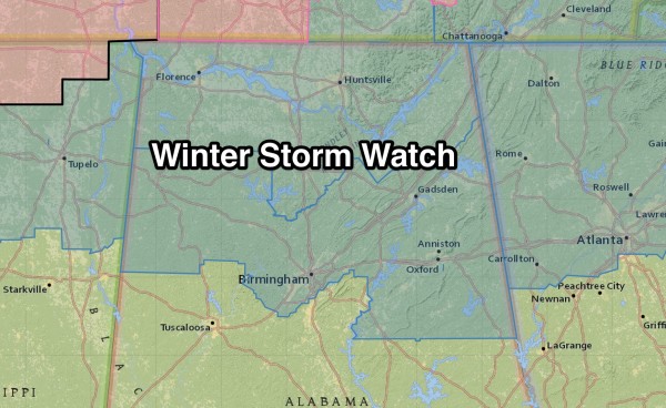
WINTER STORM WATCH: The winter storm watch remains in effect for much of North Alabama; some of the most southern counties have been removed by the NWS Birmingham (Tuscaloosa and Shelby Counties, among others, have been removed).
If model trends continue, more counties could be removed from the watch later today, and a winter storm warning will be posted for parts of North Alabama.
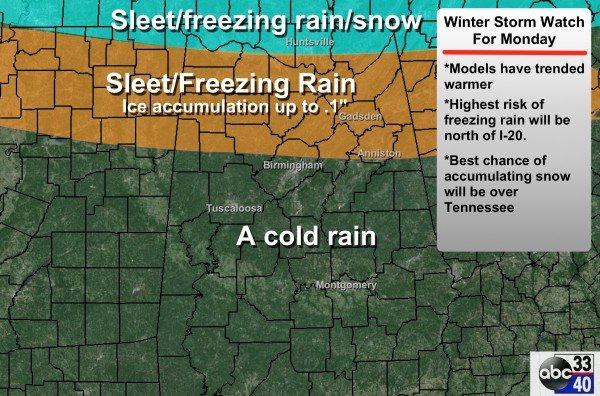
ADJUSTED FORECAST: Here is a look at our new forecast…
TIMING: Models have also trended a bit slower; looks like the precipitation will begin between 3:00 and 6:00 a.m. tomorrow. There will be no winter weather issues in Alabama through tonight other than the cold air.
PRECIPITATION TYPE/ACCUMULATION: With a more northerly track of the surface low, it looks like the best chance of accumulating snow will be over Tennessee, with potential for a bit of snow in the mix across far North Alabama, north of the Tennessee River. For most of North Alabama, it will be a sleet/freezing rain mix. We have dropped potential ice accumulation to 0.1″, however up in the Tennessee Valley amounts to 0.3″ are possible.
IMPACT: It is important to remember that 0.1″ of ice can bring big travel impacts. Cold, Arctic air is flooding Alabama this morning, and bridges and some secondary roads will become very icy tomorrow morning where temperatures remain below freezing. The good news is that no major power outages are likely with 0.1″ of ice. But again, up in far North Alabama, where ice accumulation is expected to be heavier, scattered outages are not out of the question.
PLACEMENT: As discussed yesterday, the hardest part of the forecast is defining the border between freezing rain and just a cold rain. With the model trends, we have moved the line northward in our forecast. It now appears the main chance of bridge icing/icy travel will be along and north of a line from Vernon to Fayette to Gardendale to Anniston (see the map above). Understand this line will probably be moved again later today (one way or another). It could very well be a morning when icy/dangerous travel for places like Warrior and Gardendale, and just a cold rain for downtown Birmingham and Hoover.
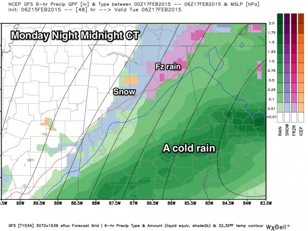
MONDAY AFTERNOON/MONDAY NIGHT/TUESDAY: The new surface low track is basically right through Central Alabama; meaning a cold, soaking rain. The rain will end late Monday night, with a chance that the rain will briefly change to snow on the back side of the departing system. For now the chance of accumulation looks rather low with minimal impact, but some icy spots sure can’t be ruled out late Monday night and early Tuesday where standing water remains. Temperatures are expected to drop into the 20s early Tuesday morning. We will have a better look at this situation later today and tonight.
ARCTIC COLD: Very cold air moves into Alabama at mid-week; the GFS is printing a low of 15 degrees for Birmingham early Thursday morning.
ALABAMA POWER IS READY, ARE YOU? Our friends at Alabama Power are monitoring the forecast closely, ready to deploy people and assets to quickly address any outages that might occur. Read a special message from Ike Piggot about their commitment to their customers.
REMEMBER: This forecast will probably change again later today and tonight, which is why we encourage you to keep a close eye on these updates as you plan for your day tomorrow. The good news is that many school systems are closed and it is a federal holiday… but some school systems are in operation and many of us do have to go to work. Stay tuned…
Category: Alabama's Weather


