Evening Update
Here some some quick notes this evening on the potential for a winter storm across Alabama Monday.
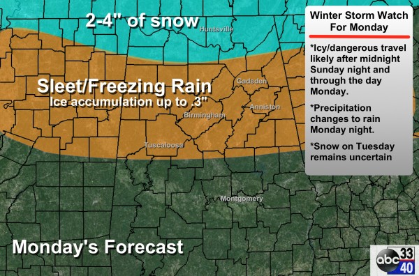
PRECIPITATION TYPE/ACCUMULATION: Main chance of snow will come over the Tennessee Valley of far North Alabama, where 2 to 4 inches are possible in spots. To the south, freezing rain and sleet are likely for places like Birmingham, Tuscaloosa, Anniston, and Gadsden.
REMEMBER: It’s very unlikely that any snow or ice amount forecast will be exactly right. Consider it to be a range of possibilities. Also, the lines on map above dividing snow from sleet from rain look very precise, but they actually have very fuzzy edges in reality.
The greatest risk of road/bridge icing will be north of a line from Aliceville to Centreville to Calera to Roanoke. Just a cold rain to the south.
TIMING: The main threat of wintry weather will come from roughly 3:00 a.m. until 3:00 p.m. Monday. A change to a cold rain will come Monday evening into Monday night, with the possible exception of the Tennessee Valley, where some ice issues could possibly linger into Monday night.
IMPACT: Driving will become difficult in these areas due to icing on bridges, and some black top roads with surface temperatures below freezing. We do not expect enough ice accumulation now for widespread power outages, but scattered outages are certainly possible. Preparing for power outages is not a bad thing to do as a course of least regret.
ALABAMA POWER IS READY, ARE YOU? Our friends at Alabama Power are monitoring the forecast closely, ready to deploy people and assets to quickly address any outages that might occur. Read a special message from Ike Piggot about their commitment to their customers.
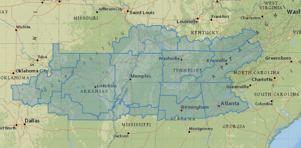
Winter storm watches are up from Oklahoma to parts of Alabama, Georgia, and Tennessee for this system.
MONDAY NIGHT/TUESDAY: For most of North/Central Alabama, we expect just a cold rain Monday night with temperatures holding just above freezing, but there remains some potential for a change to snow on Tuesday before the system moves out of the state. There is much uncertainty in this possibility, and forecast confidence is low. We will have a much more specific outlook on this early tomorrow morning; for now it remains to be seen if we will have travel impacts Tuesday, Tuesday night, or even early Wednesday.
Stay tuned for updates throughout the weekend…
Category: Alabama's Weather


