Cold and Wet; A Brighter Weekend
An all new edition of the ABC 33/40 Weather Xtreme video is available in the player on the right sidebar of the blog. You can subscribe to the Weather Xtreme video on iTunes by clicking here.
COLD RAIN CONTINUES: Periods of rain will continue across the great state of Alabama today; temperatures won’t change much during the day with most communities holding in the 40s. Additional rain amounts of 1/2 inch are likely, which should bring storm totals into the 1-2 inch range by tonight.
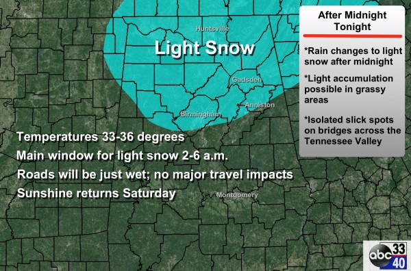
SNOW FLAKES LATE TONIGHT: As the surface low, now in the northern Gulf of Mexico, moves northeast late tonight, there is a good chance the rain will change over to light snow before ending over North Alabama. The main window for this light snow will come from about 2:00 a.m. until 6:00 a.m., so most of you will sleep right through it.
Temperatures over North/Central Alabama (places like Birmingham, Tuscaloosa, Anniston, Gadsden) should be in the mid 30s, so roads will stay just wet and there should be no travel impacts. However, up over far North Alabama’s Tennessee Valley, a few icy spots on bridges are not out of the question. But even up there widespread problems are not anticipated.
A little light accumulation is possible on grassy areas north of Birmingham, but it sure won’t stick around long.
THE ALABAMA WEEKEND: The sky will become mostly sunny by mid to late morning tomorrow, and the high will be close to 50 degrees. Sunday will be warmer, with ample sunshine and a high in the mid to upper 50s.
NEXT WEEK: An Alberta Clipper will pass northeast of Alabama Monday; we stay dry with a mix of sun and clouds along with a high around 50 degrees. Then, the rest of the week looks cool and dry with highs in the 50s, and lows in the 30s, which is right at seasonal averages for Alabama in late January.
THE LAND OF VOODOO: There has been good consistency in the idea of a storm system impacting Alabama the following weekend, around Sunday February 1 and Monday February 2. And yes, there has been evidence of some winter weather mischief, but there is no skill in a specific forecast 10 days in advance, as long time readers fully understand. Should this system form, it also will have potential to pull down some pretty cold air once it passes as the AO/NAO combo goes negative. Take some time to see the Weather Xtreme video for the maps, graphics, and more details.
THREE YEARS AGO TODAY: Eleven tornadoes touched down during the pre-dawn hours on January 23, 2012; two people were killed in Jefferson County. One of the most memorable tornadoes was an EF-3 that tore through Center Point and Clay…
WEATHER BRAINS: Don’t forget you can listen to our weekly 90 minute netcast anytime on the web, or on iTunes. This is the show all about weather featuring many familiar voices, including our meteorologists here at ABC 33/40.
CONNECT: You can find me on all of the major social networks…
Facebook
Twitter
Google Plus
Instagram
I will be doing a weather program this morning at Stemley Road Elementary School in Talladega County… look for the next Weather Xtreme video here by 4:00 this afternoon. Enjoy the day!
Category: Alabama's Weather


