Wet Is The Word
An all new edition of the ABC 33/40 Weather Xtreme video is available in the player on the right sidebar of the blog. You can subscribe to the Weather Xtreme video on iTunes by clicking here.
A COLD RAIN: We begin this second day of 2015 with low clouds, rain, and temperatures in the 40s across the great state of Alabama. Expect periods of rain through tonight; the high today will be in the low to mid 50s at best; many communities north of Birmingham will hold in the 40s all day. Not exactly Chamber of Commerce weather.
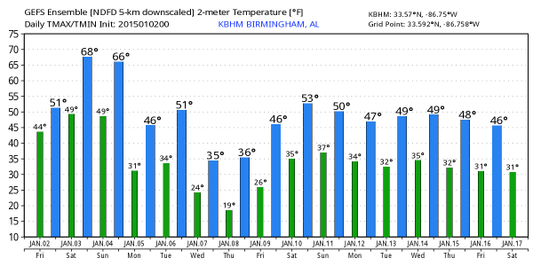
WARMER/STORMY TOMORROW: A strong low level southerly flow will push warm, unstable air northward tomorrow; the GFS is printing a high of 70 degrees for Birmingham, with dewpoints surging into the low to mid 60s by late afternoon. We will maintain a good chance of occasional showers and storms during the day, although there should be some breaks in the rain. You might even see a very brief glimpse of the sun if you are lucky between the showers.
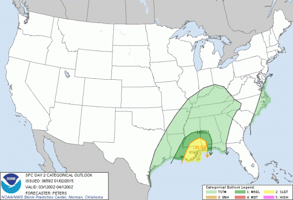
As the main dynamics approach tomorrow night, thunderstorms over Alabama will increase in coverage and intensity. SPC has defined the standard “slight risk” of severe weather for the southwest corner of the state, including Mobile, with a lower end “marginal risk” as far north as Livingston and Demopolis…
We note a low level jet of 50-60 knots along with low level bulk shear to 25 knots over the northern half of the state, but the limiting factor will be, as usual in cold season events, the degree of instability. Seems like the higher risk of severe weather will come over the southern half of the state, but dynamic weather systems like this can bring surprises, so we will watch trends closely. The higher chance of the stronger storms for Alabama will come from about 6:00 p.m. tomorrow through 3:00 a.m. Sunday.
RAIN TOTALS: Seems like most Alabama communities will see 1-2 inches of rain from this system, with isolated amounts to 3 inches. This suggests no major flooding problems, although some localized issues are certainly possible with the heavier downpours tomorrow night. There are no flash flood watches for our state.
SUNDAY: The rain will end Sunday morning; the day will be cloudy, breezy, and colder with temperatures holding in the 50s. Some North Alabama towns could fall into the 40s Sunday afternoon with a brisk northwest wind. Then, the sky will clear Sunday night as drier air works in here.
NEXT WEEK: Monday looks mostly sunny with a high in the upper 40s, but even colder air rolls in here Wednesday with a biting north wind. We might hold in the 30s all day Wednesday, followed by a low down in the 17-21 degree range at daybreak Thursday. Thankfully this “Arctic blast” won’t last too long as a warming trend begins Friday. The week looks dry with no winter precipitation worries. See the Weather Xtreme video for maps, graphics, and more details.
BIRMINGHAM BOWL: The Florida Gators will take on East Carolina in the annual Birmingham Bowl at Legion Field tomorrow; the kickoff is at 11:00 a.m. The good news is that the weather will be warmer; we project a kickoff temperature of 62 degrees, rising into the mid to upper 60s by the fourth quarter. On the negative side, occasional showers are likely, so take the rain gear.
WEATHER BRAINS: Don’t forget you can listen to our weekly 90 minute netcast anytime on the web, or on iTunes. This is the show all about weather featuring many familiar voices, including our meteorologists here at ABC 33/40.
CONNECT: You can find me on all of the major social networks…
Facebook
Twitter
Google Plus
Instagram
Thanks to Brian Peters, Bill Murray, J.P. Spann, and Meaghan Thomas for covering for me over the past few days; the time off was appreciated. I will crank out another Weather Xtreme video later today; it should be posted by 4:00 p.m. Enjoy the day!
Category: Alabama's Weather


