Heavy Rain/Strong To Severe Storms
An all new edition of the ABC 33/40 Weather Xtreme video is available in the player on the right sidebar of the blog. You can subscribe to the Weather Xtreme video on iTunes by clicking here.
ACTIVE WEATHER DAY: I always encourage you to take some time to watch the Weather Xtreme video on active days like this to see all of the maps and graphics that go along with this discussion. We will be pretty busy over the next 24 hours.
EARLY THIS MORNING: We have a few showers on radar, but nothing too heavy across North/Central Alabama. We note stronger storms over South Mississippi near a warm front, where the NWS Jackson has issued a few severe thunderstorm warnings. We also note some dense fog over the northern two-thirds of Alabama, north of a warm front to the south.
WEATHER SETUP: The warm front is about 60-70 miles north of the AL/MS Gulf Coast this morning, and moving slowly northward. A surface low will move from near Natchez, MS to a point west of Nashville late tonight, slowly deepening. And, to the west, a vigorous long wave upper trough will provide excellent dynamic support for rain and storms.
The key to the severe weather threat for the northern half of Alabama will be the northward movement of the warm front, and the mass of unstable air south of that front. Often in a situation like this, with a thick cloud cover and occasional showers, it makes for a very slow progression of the warm front. Also, cold air damming is sending cooler air into Northeast Alabama, which should help to mitigate the severe weather risk there (places like Gadsden and Fort Payne).
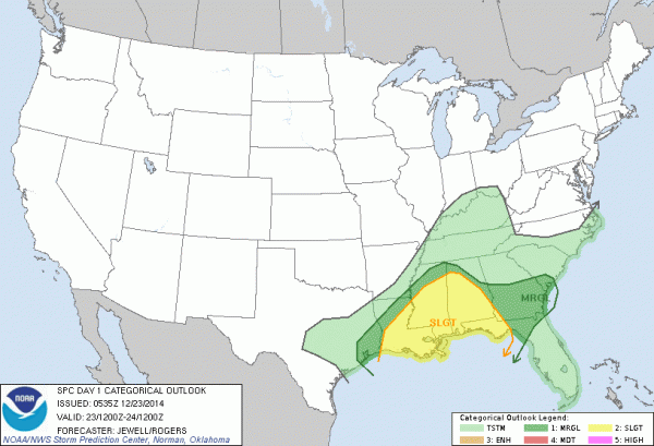
SPC has the standard “slight risk” of severe weather up today, tonight, and very early tomorrow along and south of a line from Hamilton to Leeds to Eufaula. The lower end “marginal” risk extends north to Muscle Shoals, Cullman, and Anniston. There is no formal risk defined for Gadsden or areas to the north, over Northeast Alabama.
TIMING: While we will have occasional showers and thunderstorms from now through tomorrow morning, the core severe weather threat for North/Central Alabama will come from 3:00 p.m. through 3:00 a.m. tomorrow. A few severe storms are possible before 3:00 p.m. over far West and Southwest Alabama.
THREATS: I think the most significant threat could very well be heavy rain and potential flooding; the NWS has the southern half of Alabama in a flash flood watch, and up this way a number of communities will see rain amounts of over two inches over the next 24 hours. Also the stronger storms this afternoon and tonight could produce hail, strong, possibly damaging winds, and an isolated short lived tornado or two.
CONFIDENCE: As discussed here yesterday, it just seems like the primary severe weather parameters are a little out of phase, with the low level jet and higher bulk shear values northeast of the better instability. This seems like a low end severe weather threat, but with these dynamic cold season systems can come a surprise or two. And, as I have said many times, all it takes is one tornado in the entire state that just happens to come through your neighborhood to make it a “big deal”.
CALL TO ACTION: Be sure you can hear severe weather watches and warnings. NEVER rely on an outdoor warning siren; be sure your NOAA Weather Radio is programmed properly and has fresh batteries in case of a power failure. Have a good smart phone app for warnings, like WeatherRadio by WDT, or MyWarn. And, if you have out of town guests for Christmas, be sure they know the location of your “safe place”, and know what to do in case a tornado warning is issued and you are “in the polygon”.
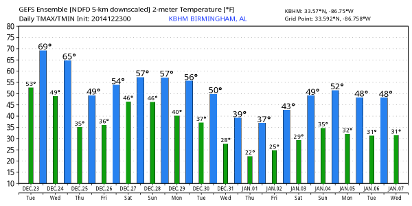
TOMORROW: Rain will end from west to east during the morning hours. The day will be breezy and cooler, with temperatures falling from near 60 at daybreak, through the 50s during the day. The sky will clear tomorrow night.
THURSDAY/FRIDAY: Christmas Day looks wonderful, with ample sunshine and a high in the 50s after starting the day in the 30s. Those temperatures are right at average values for late December in our state. We stay dry Friday with a partly to mostly sunny sky and a high around 60 degrees.
THE ALABAMA WEEKEND: Showers return to the state Saturday ahead of a cold front, and it now looks like that front will become nearly stationary, meaning we will need to continue the risk of showers into Sunday. No severe weather, and the rain probably won’t be too heavy, but just keep in mind showers are possible both days. Highs over the weekend will be in the 50s.
Drier air returns Monday.
LONG RANGE: Still seeing good evidence of much colder air reaching the Deep South toward the end of December and the first part of January; and with an active southern storm track that could pave the way for some winter weather mischief for somebody across the Deep South; there might be some weeping and gnashing of teeth in weather offices around New Year’s Eve or New Year’s Day. Again, see the Weather Xtreme video for maps and more details.
WEATHER BRAINS: Don’t forget you can listen to our weekly 90 minute netcast anytime on the web, or on iTunes. This is the show all about weather featuring many familiar voices, including our meteorologists here at ABC 33/40. Scroll down for the show notes on the new episode we recorded last night.
CONNECT: You can find me on all of the major social networks…
Facebook
Twitter
Google Plus
Instagram
If weather allows, I will produce another Weather Xtreme video by 4:00 this afternoon, and we will have updates throughout the day on the Alabama weather situation….
Category: Alabama's Weather


