Rain Ends Later This Morning; Cold Weekend Ahead
An all new edition of the ABC 33/40 Weather Xtreme video is available in the player on the right sidebar of the blog. You can subscribe to the Weather Xtreme video on iTunes by clicking here.
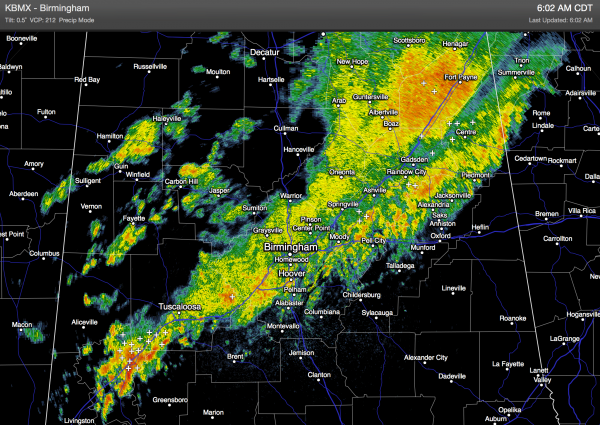
RADAR CHECK: Rain, with embedded thunderstorms, is moving through North/Central Alabama at daybreak.
Nothing severe, and rain amounts should be generally under 1/2 inch. The rain will end from northwest to southeast during the late morning hours.
Expect a clearing sky this afternoon, and the weather turns cooler as most communities will hold in the 60s today.
Tomorrow will be a bright, sunny, pleasant fall day with a high in the upper 60s.
COLD AIR ARRIVES THIS WEEKEND: North winds will really pick up across Alabama late Friday and Friday night as the coldest air so far this season blows into the state. It will be blustery for the trick or treaters Friday evening with falling temperatures, and a north wind of 12-22 mph.
Temperatures will drop to near the freezing mark by daybreak Saturday, easily the coldest morning so far this season.
We project a high Saturday only in the 50-55 degree range, with a gusty north wind making it feel colder. But, the air will be dry and the sky will be sunny.
Sunday morning’s lows will range from 28 to 34 degrees with widespread frost likely as the wind goes calm. Then, Sunday will be sunny with a high in the mid to upper 50s. At least the wind will be relatively light, unlike Saturday.
NORTHEAST OF ALABAMA: Places like Gatlinburg, Tennessee and Snowshoe Mountain, West Virginia should see their first snow flakes of the season as a coastal low forms near the mouth of Chesapeake Bay.
FOOTBALL WEATHER: For Friday night’s high school games, it will be clear, windy, and sharply colder with temperatures falling through the 50s, reaching the 40s by the second half of the games. North winds will gust to 25 mph at times, making it feel colder.
Auburn will be on the road; they play at Ole Miss in Oxford Saturday evening (kickoff 6p CT). The sky will be clear, temperatures will fall from 50 degrees at kickoff down to near 40 degrees by the fourth quarter. Perfect cool, crisp night for football.
UAB is also on the road; they play at Florida Atlantic in Boca Raton, FL Saturday evening (5p CT kickoff). Again, a clear sky is likely with temperatures falling from near 80 at kickoff to the mid 70s by the fourth quarter.
NEXT WEEK: Expect dry weather Monday and Tuesday with a slow warming trend; the latest GFS run has backed off on the Wednesday rain event; see the Weather Xtreme video for the maps, graphics, and details.
TROPICS: A disturbance just northeast of the Leeward Islands could develop slowly in coming days, but it is moving north, and will not impact the U.S.
GULF COAST WEATHER: A few showers are likely on the coast this afternoon from Panama City over to Gulf Shores, but expect sunny days and clear nights tomorrow through the weekend. It will be sharply colder on the coast Saturday and Sunday with highs around 60, and lows in the upper 40s.
WEATHER BRAINS: Don’t forget you can listen to our weekly 90 minute netcast anytime on the web, or on iTunes. This is the show all about weather featuring many familiar voices, including our meteorologists here at ABC 33/40.
CONNECT: You can find me on all of the major social networks…
Facebook
Twitter
Google Plus
Instagram
I will be speaking this morning to a senior adult group in Southside, in Etowah County, and this evening I will be live from opening night of Disney on Ice at the BJCC, which is also the kickoff for our annual Toys for Tots drive. I will post updated forecast notes here later this afternoon… enjoy the day…
Category: Alabama's Weather


