Cold Front Arrives Late This Week
An all new edition of the ABC 33/40 Weather Xtreme video is available in the player on the right sidebar of the blog. You can subscribe to the Weather Xtreme video on iTunes by clicking here.
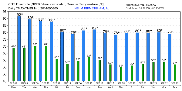
STILL WARM AND HUMID THROUGH MID-WEEK: Alabama’s weather won’t change very much through Wednesday; warm, humid days with a mix of sun and clouds, and the risk of a few showers and storms each afternoon. The storms should be pretty widely spaced, and afternoon highs will be in the 88-91 degree range, just above average for early September in Alabama (Birmingham’s average high for September 8 is 87 degrees). Humidity levels will remain rather high with a summer feel.
PATTERN CHANGE AHEAD: A deep surface low will form over the Great Plains tomorrow, moving to the Great Lakes Wednesday. This will pull a cold front southward, the leading edge of much cooler air that is now over Canada. A fairly significant severe weather threat is setting up south and east of the surface low on these two days over the northern U.S.
This cold front will push into Alabama Thursday night, and an organized band of showers and storms should push through our state. No severe weather is expected here, as the main surface low and dynamic support will remain to the north. Looks like the main window for showers and storms ahead of the front will come from about 4:00 p.m. Thursday through 4:00 a.m. Friday; rain amounts of around 1/2 inch can be expected.
REFRESHING CHANGE: The sky becomes partly to mostly sunny Friday, with a fresh north breeze and lower humidity, and the weekend ahead will be very nice with ample sunshine Saturday and Sunday, low humidity, and pleasant highs. Looks like the high will be in the low 80s over the weekend, with early morning lows in the 58-62 degree range.
You won’t need jackets or sweaters this weekend, but it will be more comfortable at high school and college football games. No threat of storms, lower humidity levels, and cooler nights.
The dry weather continues into at least the first half of next week; see the Weather Xtreme video for maps, graphics, and details.
TROPICS: The Atlantic basin remains very quiet at a time when the tropics should be peaking. There is a new wave coming off the coast of Africa with some chance of development; it will move west-northwest in coming days in a relatively dry airmass. Remains to be seen if this will develop at all, recurve, or be some threat to land. We will keep an eye on it.
GULF COAST FORECAST: Pretty typical early September weather from Panama City over to Gulf Shores this week; about 6 to 8 hours of sunshine each day with the risk of scattered thunderstorms; highs will be in the upper 80s on the immediate coast, and the sea water temperature this morning at the Dauphin Island Sea Lab is 85 degrees. The cooler and drier air will have a hard time reach the coast this weekend, but showers will become fewer in number, most likely, by Saturday and Sunday.
WEATHER BRAINS: Don’t forget you can listen to our weekly 90 minute netcast anytime on the web, or on iTunes. This is the show all about weather featuring many familiar voices, including our meteorologists here at ABC 33/40. We will produce this week’s show tonight at 8:30 CT… you can watch it on “James Spann 24/7” on cable systems around the state, or on the web here.
CONNECT: You can find me on all of the major social networks…
Facebook
Twitter
Google Plus
Instagram
I will be doing a weather program today at Deer Valley Elementary School in Hoover… look for the next Weather Xtreme video here by 4:00 this afternoon. Enjoy the day!
Category: Alabama's Weather


