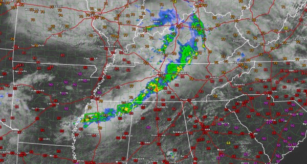
Showers and Storms Pushing Into Northwest Alabama
At late morning, a surface low was over northern Kentucky, near Owensboro. This feature is depicted well on satellite imagery and radar reflectivity loops. An upper low was over southern Illinois, with a trough trailing back into Arkansas and northern Texas. Showers and storms developed this morning from southwestern Tennessee into northern Mississippi ahead of the trough, which is progressing eastward with the upper low.
The trough is tapping some deeper moisture that you find back over Texas and heavy rain has been the result. There was a flash flood warning over the Delta of northwestern Mississippi where 2-4 inches of rain fell in 3 hours with additional rain falling.
The forecast for your Sunday will be influenced by that disturbance and those showers/storms. Indications are that they will settle into Northwest Alabama through the early afternoon and try to settle toward the I-20 corridor. But they should weaken as they drop into that drier air we mentioned two paragraphs ago. They may hold together enough to bring showers and weakening storms to the I-20 corridor.
So, expect increasing clouds northwest of I-59 into the afternoon with a chance of showers and storms. Highs will generally be in the lower 90s. Expect a warm and humid evening with lows in the 70s. There will be a small chance of showers.
The trough will slide a little east tonight and will be over us tomorrow, leading to increasing shower and thunderstorm chances. Highs will top out around 90F, with about a 50-60% chance of rain and thunderstorms.
Category: Alabama's Weather


