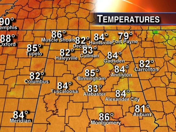
No 90s Again Today
An all new edition of the ABC 33/40 Weather Xtreme video is available in the player on the right sidebar of the blog. You can subscribe to the Weather Xtreme video on iTunes by clicking here.
“COOL” SUMMER CONTINUES: Today is the 8th consecutive day for Birmingham with a high under 90 degrees; clouds and showers are keeping temperatures down.
Scattered showers and storms are in progress, moving from east to west around the top of an upper low that is over the Mississippi Gulf Coast. Those showers will fade away later tonight.
TOMORROW AND THURSDAY: Moist air stays in place, and we will mention the risk of “scattered, mostly afternoon and evening showers and thunderstorms” tomorrow with a high in the 87-90 degree range. Then, look for an increase in the number of showers and storms Thursday afternoon and Thursday night as a surface front moves down into North Alabama.
DRIER FRIDAY/SATURDAY: The weather looks generally rain-free for the northern half of Alabama on these two days with lower humidity levels; the risk of scattered showers and storms will continue over the southern counties of the state. Afternoon highs will be around 90 degrees, and we should drop into the 60s early Saturday morning.
SUNDAY/MONDAY: The chance of showers and storms will increase again on these two days; moist air returns Sunday, and a cold front will approach Monday from the north. The high will drop back into the mid to upper 80s because of clouds and showers.
ANOTHER “COOL” SHOT NEXT WEEK: Global models are in good agreement; a vigorous long wave upper trough will form over the eastern half of the nation, pulling down cooler, drier continental air into Alabama Tuesday through Thursday. Looks like we have a chance of going down into the 50s again Wednesday morning, close to record levels for the end of July. This will be one of the coolest Julys on record for many Alabama reporting stations if this verifies.
TROPICAL DEPRESSION TWO: TD 2 in the Atlantic, about 800 miles east of the Lesser Antilles, is expected to dissipate, or become a remnant low by the time it reaches the islands due to very dry air surrounding the system, and harsh winds aloft. The rest of the Atlantic basin is quiet.
GULF COAST WEATHER: We project about 6 to 8 hours of sunshine each day on the Gulf Coast through the weekend (from Panama City to Gulf Shores) with the usual daily risk of scattered showers and thunderstorms. Highs will remain in the mid to upper 80s on the immediate coast, and sea water temperatures are mostly in the mid 80s.
WEATHER BRAINS: Don’t forget you can listen to our weekly 90 minute netcast anytime on the web, or on iTunes. This is the show all about weather featuring many familiar voices, including our meteorologists here at ABC 33/40. We enjoyed having Oklahoma City TV meteorologist Gary England on the show last night… scroll down for the show notes.
CONNECT: You can find me on all of the major social networks…
Facebook
Twitter
Google Plus
Instagram
I enjoyed speaking to the residents at St. Martin’s in the Pines in Birmingham today… be looking for the next Weather Xtreme video here by 7:00 a.m. tomorrow…
Category: Alabama's Weather


