Storms Tonight; Cooler Through Mid-Week
An all new edition of the ABC 33/40 Weather Xtreme video is available in the player on the right sidebar of the blog. You can subscribe to the Weather Xtreme video on iTunes by clicking here.
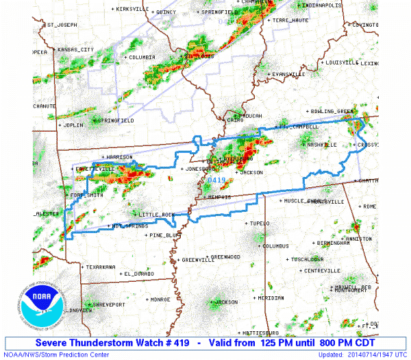
BIG CHANGES AHEAD: A high amplitude upper air pattern is developing over the continental U.S…. and a deep upper trough over the eastern states promises to bring some unusual weather for July. Ahead of the cold front, showers and storms will impact the state tonight and tomorrow. North of here, SPC has a severe thunderstorm watch up until 8pm CT for parts of Mississippi, Tennessee, and Arkansas…
The storms will move into our state tonight, but they should be weakening as they drop south. Still, a few strong storms are certainly possible over the northern third of the state with gusty winds and some small hail. The storms should reach Birmingham, Tuscaloosa, Anniston, and Gadsden after midnight.
TOMORROW: Showers and storms during the morning should taper off during the midday hours as drier air begins to move into North Alabama, and you will notice a real difference tomorrow night; we will drop into the 57-61 degree range by daybreak Wednesday.
WEDNESDAY/THURSDAY: These two days will be delightful for the middle of July. Mostly sunny days, lower humidity levels, and cool nights. Thursday morning will be cool as well with 50s likely for colder pockets. The record low (at Birmingham) for July 17 is in danger… the current record is 62 set in 1965.
FRIDAY AND THE WEEKEND: The weather changes again as moisture surges northward Thursday night, and we will forecast occasional showers and thunderstorms Friday and Saturday. The sky will be mostly cloudy both days with highs in the mid 80s. A chance of showers and thunderstorms will continue on Sunday, although the showers could be fewer in number by then with intervals of sunshine returning.
NEXT WEEK: A strong upper high will be anchored over the Southwest U.S. where there will be searing heat… we will be on the eastern flank of the upper high with a northwest flow aloft. This should keep our weather unsettled at least for the first half of the week with waves coming down from the northwest. See the Weather Xtreme video for maps, graphics, and details.
GULF COAST WEATHER: A few passing showers and storms are likely tomorrow along the coast from Panama City to Gulf Shores, but it won’t rain all day and the sun will be out at times. Then, Wednesday through the weekend, pretty routine summer weather can be expected with about 6 to 8 hours of sunshine each day with a few scattered storms around as usual. Highs along the immediate coast will be in the upper 80s, and sea water temperatures are mostly in the mid 80s.
TROPICS: The Atlantic basin remains very quiet, and tropical storm formation is not expected through the week.
WEATHER BRAINS: Don’t forget you can listen to our weekly 90 minute netcast anytime on the web, or on iTunes. This is the show all about weather featuring many familiar voices, including our meteorologists here at ABC 33/40. We will produce this week’s show tonight at 8:30 CT… you can watch it on “James Spann 24/7” on cable systems around the state, or on the web here.
CONNECT: You can find me on all of the major social networks…
Facebook
Twitter
Google Plus
Instagram
I enjoyed seeing the kids in the summer program at Clay Elementary School… be looking for them on the Pepsi KIDCAM today at 5:00 on ABC 33/40 News! The next Weather Xtreme video will be posted here by 7:00 a.m. tomorrow….
Category: Alabama's Weather


