Heat/Humidity Levels Rising
An all new edition of the ABC 33/40 Weather Xtreme video is available in the player on the right sidebar of the blog. You can subscribe to the Weather Xtreme video on iTunes by clicking here.
BACK IN THE SADDLE: Thanks to Bill Murray, Brian Peters, Meaghan Thomas, and the gang for allowing me to have little down time, which was needed and appreciated. In today’s world of media meteorology, I work 18 hour days (no exaggeration), and getting “off the grid” is something you have to do on occasion. But, always good to be back at it.
What a Fourth of July weekend… with low humidity and record lows across the great state of Alabama. It will never get much better in mid-summer around here.
HEATING UP: The last time we had a high at or over 90 degrees was back on July 2, and we have a good chance of reaching 90 (or slightly higher) today as heat and humidity levels rise across the Deep South. The sky will be partly to mostly sunny, and while a few isolated showers could pop up this afternoon, the chance of any one spot getting wet is only about one in ten.
Not much overall change tomorrow, although the risk of an afternoon shower will be a little higher over the northern third of the state.
WEDNESDAY/THURSDAY: These two days will offer the best chance of showers and thunderstorms as a surface front drops down toward the Alabama/Tennessee state line and becomes stationary. We will project scattered to numerous showers and storms both days, with highs back in the mid to upper 80s because of the clouds and showers. A few strong storms are possible Wednesday afternoon; SPC has low end 5 percent severe weather possibilities in place across much of the state.
FRIDAY AND THE WEEKEND: The GFS suggests that drier air could creep into North Alabama Friday, with the higher risk of a shower or storm moving down into the southern half of the state. Then, the front dissipates over the weekend with rising heat levels and few showers. Bottom line is that the weekend for now is looking mostly hot and dry with only isolated showers… highs should be up in the low to mid 90s.
Showers and storms could show an increase early next week as a weakness in the upper ridge develops. See the Weather Xtreme video for the maps, graphics, and details.
AT THE BEACH: The weather looks good this week… from Panama City over to Gulf Shores expect about 7 to 9 hours of sunshine each day with only widely scattered thunderstorms. Highs will be in the upper 80s on the immediate coast, and the sea water temperature this morning at the Dauphin Island Sea Lab is 81 degrees.
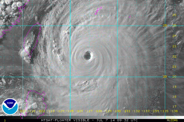
TROPICS: The Atlantic basin should be quiet all week as the dry, Saharan dust layer is evident. But, over in the western Pacific, Super Typhoon Neoguri is packing sustained winds of over 150 mph…
It will skirt by Okinawa tomorrow, and then move up into southern Japan Wednesday. Thankfully it will be weakening as it moves into Japan, but it will still pack a punch.
WEATHER BRAINS: Don’t forget you can listen to our weekly 90 minute netcast anytime on the web, or on iTunes. This is the show all about weather featuring many familiar voices, including our meteorologists here at ABC 33/40. We will produce this week’s show tonight at 8:30 CT… you can watch it on “James Spann 24/7” on cable systems around the state, or on the web here.
CONNECT: You can find me on all of the major social networks…
Facebook
Twitter
Google Plus
Instagram
Look for the next Weather Xtreme video here by 4:00 or so this afternoon… enjoy the day!
Category: Alabama's Weather


