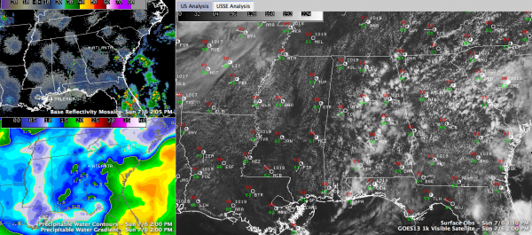
A Few Showers Return
A very nice early July Sunday is in progress across Central Alabama. Things are returning to normal quickly in the temperature and moisture department across Alabama. Precipitable water values are getting back to 1.5 inches across the state, as evidenced in the lower left panel of the graphic. Temperatures are climbing through the middle 80s for the most part but were already near 90F at Tuscaloosa. You can see the nice field of cumulus clouds which are a byproduct of the increased moisture. A few showers were starting to show up over East Central and South Central Alabama, from Alex City to Montgomery to Greenville over to LaGrange, Georgia. The pulse thunderstorms are drifting aimlessly to the northwest for the most part.
MyWARN SEVERE WEATHER TODAY: Severe weather is likely today across parts of Wisconsin, southeastern Minnesota, eastern Iowa, northeastern Iowa and northern Illinois. The culprit is a surface low that is moving from Minnesota to Wisconsin.
TROPICS: The post tropical low that was Arthur is skirting Newfoundland this morning. There is a trough of low pressure southeast of Georgia coast that is triggering widespread showers and storms. It is not recognized as a disturbance yet by the NHC and development is not expected. But it is another case of where we will probably see our tropical cyclones develop for the most part this year: close in to the U.S.
Category: Alabama's Weather, Tropical


