Afternoon Storms Remain Possible
An all new edition of the ABC 33/40 Weather Xtreme video is available in the player on the right sidebar of the blog. You can subscribe to the Weather Xtreme video on iTunes by clicking here.
METEOROLOGICAL SUMMER IS HERE: It is the time of the year when we can say “hot and humid with the chance of an afternoon thunderstorm in spots” and be correct 99 percent of the time through Labor Day. See this post I wrote a few years ago about summer weather forecasting in Alabama.
TODAY/TOMORROW: A “wedge” of drier air has slipped into Northeast Alabama… so those of you in counties like Jackson and DeKalb won’t have much rain around. But, for the rest of the state, look for a mix of sun and clouds today and tomorrow, and again we will be dodging “scattered, mostly afternoon and evening showers and thunderstorms”. The chance of any one spot getting wet today and tomorrow is about fifty/fifty, and highs will be in the low to mid 80s. The average high for June 2 is 85 degrees (for Birmingham).
WEDNESDAY: An upper high west of the state will ease in here, and the warmer air aloft should mean a more stable atmosphere, and accordingly showers should thin out greatly. In fact, the GFS and the NAM suggest the chance of any one community seeing rain Wednesday afternoon is only in the 10 percent range. Looks like the driest day of the week.
THURSDAY/FRIDAY: A weak surface front will approach from the north as the upper high weakens a bit, and we will mention the risk of a few showers and storms both days. On Thursday, showers and storms should be a little more active over the northern third of the state, with the activity on Friday over much of North and Central Alabama. It won’t rain all day, and it won’t rain everywhere, but a passing shower or storm is a pretty good possibility both days, especially during the afternoon and evening hours. Highs will be in the upper 80s.
THE ALABAMA WEEKEND: The front will wash out before bringing any drier air into Alabama, so for now we expect pretty routine early summer weather. Partly sunny days, and the risk of a few scattered showers and storms both afternoons. Highs between 86 and 90.
AT THE BEACH: A few showers and storms will fire up later today on the coast from Panama City to Gulf Shores, but the weather for the rest of the week and the upcoming weekend looks great, with about 8 to 10 hours of sunshine each day with only isolated showers or thunderstorms. Highs will be in the 80s on the immediate coast, and the sea water temperature this morning at the Dauphin Island Sea Lab is 77 degrees.
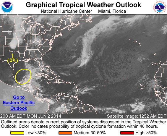
TROPICS: Hurricane season in the Atlantic basin started yesterday… NHC is looking at disturbed weather over the southwest Gulf of Mexico; no development is expected anytime soon, and SSTs (sea surface temperatures) in the Gulf remain fairly cool, especially over the northern Gulf.
WEATHER BRAINS: Don’t forget you can listen to our weekly 90 minute netcast anytime on the web, or on iTunes. This is the show all about weather featuring many familiar voices, including our meteorologists here at ABC 33/40. We will produce this week’s show tonight at 8:30 CT… watch it on “James Spann 24/7” on cable systems around the state, or on the web here.
CONNECT: You can find me on all of the major social networks…
Facebook
Twitter
Google Plus
Instagram
Look for the next Weather Xtreme video here by 4:00 this afternoon… enjoy the day!
Category: Alabama's Weather


