Sun and Scattered Storms
An all new edition of the ABC 33/40 Weather Xtreme video is available in the player on the right sidebar of the blog. You can subscribe to the Weather Xtreme video on iTunes by clicking here.
ROUTINE EARLY SUMMER WEATHER: We are getting into that time of the year when our weather doesn’t change much. Just about every day between now and the end of August you can say “hot and humid with the chance of an afternoon storm in a few spots”, and be correct. If you are new to Alabama, you can read more about summer weather forecasting on this post I put together a few years ago, but it still very relevant.
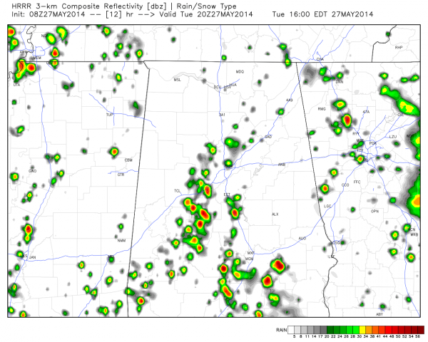
The radar is quiet this morning, but we expect a few scattered storms this afternoon and tonight thanks to the daytime heating process, which will make air parcels buoyant, and also the slow approach of an upper low now over the Texas Panhandle. This is the HRRR depiction of what the radar might look like at 3:00 this afternoon…
Chance of any one spot getting wet later today is about one in three, and the high should be in the upper 80s in most places.
TOMORROW AND THURSDAY: The upper low will get closer, and bring colder air aloft and more unstable conditions, so there should be an increase in the number of scattered showers and storms tomorrow and Thursday. Still, it won’t rain everywhere, and it won’t rain all day, and the sun will be out at times. The best chance of a shower or storm will come during the afternoon and evening hours, but a late night or morning shower can’t be ruled out. Highs will be in the mid 80s.
FRIDAY AND THE WEEKEND: The upper feature will lift out and wash out, leaving us in a warm, moist airmass. A weak “back door” cold front will approach from the north Saturday, but the 00Z GFS suggests it won’t make it past the northeast corner of our state. Bottom line is that we will continue the idea of “scattered, mostly afternoon and evening showers and storms” with a mix of sun and clouds each day. Highs will be mostly in the 87 to 90 degree range.
LAND OF VOODOO: The GFS is hinting at some tropical mischief in the Gulf of Mexico June 4-7… see the Weather Xtreme video for details. The Atlantic basin hurricane season begins Sunday, which is also the first day of meteorological summer.
GULF COAST WEATHER: Mostly sunny weather continues today from Panama City over to Gulf Shores, but we will bring in a chance of scattered showers and thunderstorms tomorrow through Friday with about 4 to 5 hours of sunshine each day. For the upcoming weekend the showers become more widely spaced with increasing amounts of sunshine. Highs will be in the 80s on the coast, and closer to 90 inland.
WEATHER BRAINS: Don’t forget you can listen to our weekly 90 minute netcast anytime on the web, or on iTunes. This is the show all about weather featuring many familiar voices, including our meteorologists here at ABC 33/40. We will produce this week’s show Thursday at 8:30p CT.
CONNECT: You can find me on all of the major social networks…
Facebook
Twitter
Google Plus
Instagram
Look for the next Weather Xtreme video here by 4:00 this afternoon…. enjoy the day…
Category: Alabama's Weather


