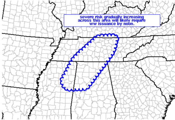
Severe Thunderstorm Watch Coming Soon
The SPC continues to monitor trends across Alabama and the Mid-South this morning. Much of the state remains outlined in a slight risk for severe weather today. As we head through the day, and the atmosphere becomes a bit more favorable for thunderstorms, a severe thunderstorm watch will be needed. The SPC is currently working with local NWS offices in the affected areas on the a new watch that will be issued soon. Still waiting to see if Central Alabama will be included in the watch.
The main concern with storms today remains the threat for damaging wind gusts, hail, and very heavy rainfall.
AREAS AFFECTED…NERN MS/NRN AL/MIDDLE TN AND VICINITY
CONCERNING…SEVERE POTENTIAL…WATCH LIKELY
VALID 141556Z – 141800Z
PROBABILITY OF WATCH ISSUANCE…80 PERCENT
SUMMARY…INCREASING RISK FOR SEVERE STORMS OVER THE NEXT COUPLE OF
HOURS SUGGESTS WW ISSUANCE WILL BECOME LIKELY THROUGH NOON.
DISCUSSION…WV LOOP ACROSS THE MID SOUTH/CENTRAL GULF-COAST REGION
SHOWS LARGE-SCALE ASCENT INCREASING ATTM…AHEAD OF A VORT MAX NOW
CROSSING THE NERN TX/ERN OK VICINITY. WHILE CLOUD COVER —
ESPECIALLY INTO MS/AL — IS LIMITING HEATING TO SOME
DEGREE…DEWPOINTS RANGING FROM THE MID 60S TO LOWER 70S WILL
SUPPORT A CONTINUED DIURNAL INCREASE IN CAPE /ATTM INTO THE 1000 TO
1500 J/KG RANGE FOR SURFACE-BASED PARCELS PER OBJECTIVE ANALYSES/.
WITH DEEP-LAYER SHEAR SUPPORTIVE OF ORGANIZED/ROTATING STORMS…AND
AREA VWPS HINTING AT A GRADUAL INCREASE IN FLOW MAGNITUDE ABOVE 900
MB — CONFIRMING A STRENGTHENING TREND IN LOW- TO MID-LEVEL FLOW PER
12Z MODEL FORECASTS — THE OVERALL ENVIRONMENT WILL BECOME
INCREASINGLY SUPPORTIVE OF SEVERE STORMS WITH TIME. AS THE
OBSERVED/GRADUAL INCREASE IN CONVECTION /PER LATEST RADAR IMAGERY/
CONTINUES…SEVERE RISK — INCLUDING POTENTIAL FOR DAMAGING WINDS
AND A TORNADO OR TWO — WILL LIKEWISE INCREASE ACROSS THIS REGION.
Category: Alabama's Weather, Severe Weather


