Big Tornadoes to Our Northwest Tonight. Our Turn Tomorrow?
It has been a frightening afternoon and night in areas to the northwest of Alabama.
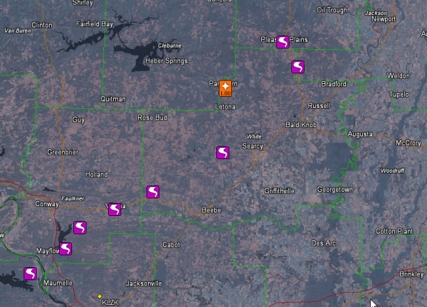
Arkansas is the hardest hit state. A long track tornado affected areas northwest to north to northeast of Little Rock starting just after 7 p.m.
A tornado was reported on the ground near Roland at 7:25. Three fatalities are being reported in Pulaski County, where the tornado apparently first touched down.
The tornado crossed I-40 with devastating effect a short time later. Portions of I-40 are still shut down.
Major damage was reported near Mayflower a few minutes later.
Around 7:39, homes were damaged in Saltillo.
There is a disaster tonight in Vilonia, AR where the tornado next struck at 7:39 p.m. A fast food restaurant was damaged as well as numerous homes. Local officials reported “mass casualties,” which doesn’t necessarily mean lots of fatalities, but certainly many injuries.
Around 8:01, the tornado passed one mile north of El Paso AR.
At 8:21, it was 6 miles west of Searcy AR, narrowly missing the larger town to the northwest.
At 8:50, the tornado was reported near Denmark, or southeast of Pleasant Plains.
At 9:05 p.m., a tornado was reported at Macks in Jackson County and five minutes later a few miles northeast of there at Jacksonport and a short time later west of Campbell Station.
Here are these reports plotted on a map:
IN KANSAS
Also, a little earlier, a tornado was reported in downtown Baxter Springs KS around 5:39. 60-80 homes are reported destroyed. Another 20-25 businesses have been damaged. But fortunately, the casualty count there appears to be low.
FOR US IN ALABAMA
This is still a developing situation. The activity that caused the tornadoes in Arkansas will not affect our state tonight. It will push through northeastern Arkansas, southeastern Missouri and into Northwest Tennessee and western Kentucky overnight.
It looks like activity that forms later tonight in eastern Texas and Arkansas will move quickly across Mississippi overnight, but will weaken as it moves into Alabama.
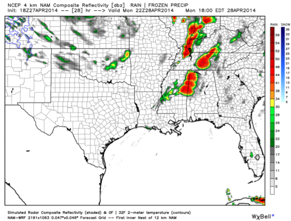
Additional thunderstorms will form by lunchtime over eastern Mississippi. These storms could become severe as they push into West Alabama during the early afternoon. Here is the 4km NAM simulated radar for 1 p.m.
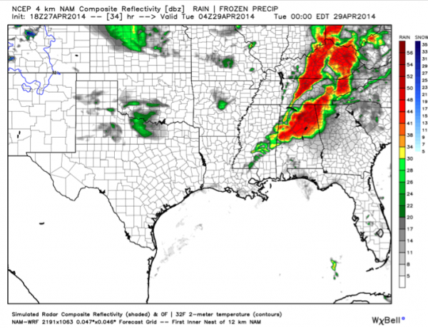
They will slowly spread eastward across the state through the afternoon and evening. Here is the same product around 6 p.m.
They should be southeast of I-5 by 9-10 p.m., but will continue to affect areas southeast of Birmingham during the late night hours.
LIKE APRIL 15, 2011?
Kevin Laws from the NWS just penned an excellent mesoscale discussion that echoed something I had just said to Ryan Stinnett. It looks similar to past outbreaks like the April 15, 2011 outbreak. That is a forgotten outbreak, because it came two weeks before April 27th. But it produced 29 tornadoes in the NWS Birmingham county warning area and killed four people.
TUESDAY
And as Kevin says in his discussion, Tuesday is still up in the air. Let’s get into the action tomorrow before we start worrying about it.
Category: Headlines, Severe Weather


