Latest Outlook for Monday
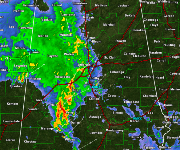
Showers and storms continue to move through Central Alabama this afternoon. With these storms, there is moderate to heavy rain falling, as well as quite a bit of lightning and thunder. Some of the more intense cells could be producing gusty winds and small hail. No storms are severe, and we are not expecting severe weather across Alabama today.
The front edge and stronger convection is approaching Interstate 65. Behind the leading edge of the activity, moderate rain will continue to fall for a couple of hours. This activity is associated with the warm front that is lifting north today. Behind the front, warm and moist air we be streaming north out of the Gulf of Mexico.
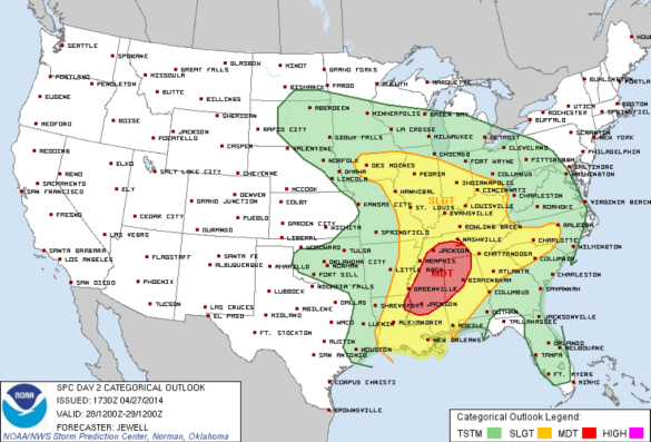
The latest day two convective outlook from the SPC continues to highlight the very dangerous threat of severe weather we are expected to see Monday and Monday night across the state. The SPC maintains much of the state in a risk for severe weather with locations in North-Central Alabama outlined in an enhanced threat for severe weather with a moderate risk. This moderate risk is roughly along and north of the Interstate 59 corridor, and includes Birmingham, Tuscaloosa, Jasper, Cullman, Huntsville, Decatur, Florence and Hamilton.
A widespread and organized severe weather outbreak is expected tomorrow for portions of Alabama, Mississippi, Louisiana, Tennessee, as well as adjacent states. Very large hail, damaging winds, strong tornadoes, and flash flooding are expected in these areas.
Tomorrow afternoon is when the worst of the weather is expected to develop over northern Mississippi. This activity will then begin to move east and will be entering Alabama during the evening hours and will last into the overnight hours over the state.
Category: Alabama's Weather, Severe Weather


