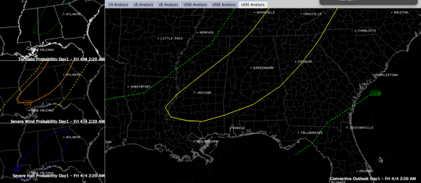
Slight Risk for Much of Central Alabama Later Today
No changes in thinking this morning on the severe weather threat.
A mesoscale convective system is pushing eastward across southern Arkansas early this morning, trailing southwestward into northern Louisiana and northeastern Texas.
The activity is still nearly four hours west of the Alabama border.
The new SPC Day One Severe Weather Outlook is out. It includes the standard slight risk for all of Central Alabama except for the I-85 corridor, and excludes Franklin, Colbert and Lauderdale Counties in Northwest Alabama.
This is the outlook that goes into effect at 7 a.m. CDT:
It reflects the expected weakening of the storm complex to our west tonight and foretells of more development by afternoon ahead of the cold front. The afternoon storms will present the threat of damaging winds and hail, but the tornado threat will be negligible.
Here is the text of the new Day One:
…CUMBERLAND PLATEAU TO MS/AL..
EXTENSIVE CONVECTIVE OVERTURNING IS PREVALENT FROM THE LOWER OH
VALLEY TO TEXARKANA THIS MORNING. MOST OF THIS ACTIVITY SHOULD BE
ONGOING AT 12Z WITHIN A SWATH OF 50S/60S SURFACE DEW POINTS AND
SUFFICIENT DEEP-LAYER SHEAR FOR ORGANIZED LINE SEGMENTS. BUT
CONVECTION SHOULD LARGELY OUTPACE THE PLUME OF MODERATE TO STRONG
INSTABILITY W OF THE LOWER MS VALLEY. IN ADDITION…LOW-LEVEL WINDS
AND FORCING FOR ASCENT WILL SUBSIDE WITH SRN EXTENT AS THE PRIMARY
CYCLONE SHIFTS NEWD. THUS…MCS/S SHOULD BE IN A WEAKENING STATE
DURING THE LATE MORNING…BUT WITH A RISK FOR ISOLATED DAMAGING
WINDS. IN THE WAKE OF MORNING ACTIVITY WHERE POCKETS OF STRONGER
HEATING OCCUR…ISOLATED STORMS SHOULD DEVELOP ALONG THE COLD FRONT.
A MODEST COMBINATION OF SHEAR/INSTABILITY/LIFT MAY POSE A SEPARATE
/LARGELY MARGINAL/ SEVERE RISK.
Category: Alabama's Weather, Headlines, Severe Weather


