Warming Up; Rain Ahead
An all new edition of the ABC 33/40 Weather Xtreme video is available in the player on the right sidebar of the blog. You can subscribe to the Weather Xtreme video on iTunes by clicking here.
THIS MORNING: Temperatures have been slowly rising over the past few hours across Alabama thanks to clouds and a southerly breeze; some of the colder pockets were below freezing overnight. But, at daybreak, most communities are in the 40s. We do note a few sprinkles on radar at daybreak over North Alabama.
The day ahead will be generally dry with mix of sun and clouds; the high will be in the 67-70 degree range as a warming trend begins. Showers become more likely late tonight after midnight.
TO THE WEST: SPC has the standard “slight risk” of severe weather up for much of Arkansas and Missouri this afternoon and tonight as a surface low deepens over the High Plains.
TOMORROW: The storms to the west will move into Alabama tomorrow morning, but the dynamic support will move well to the north of here, and with marginal instability I do not expect any severe weather. I believe the most organized storms will be from about 5:00 a.m. until 1:00 p.m.
There should be a relative lull in the rain tomorrow afternoon and early tomorrow night. Still, a few showers could be around, but nothing too widespread. The Birmingham Barons host the Chicago White Sox at Regions Field in downtown Birmingham tomorrow evening; a very good chance they get the game in, and temperatures will be very comfortable (upper 60s). Just, a passing shower is certainly possible.
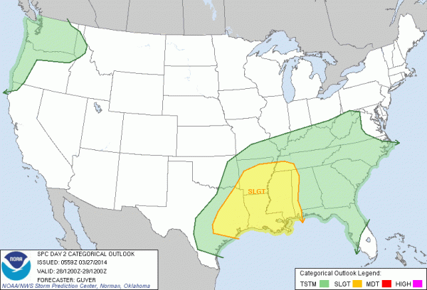
ROUND TWO: A secondary low will form just northwest of Alabama tomorrow night, and a second round of showers and storms will impact our state late tomorrow night into early Saturday morning. SPC has the far western part of Alabama under a “slight risk” for this…
The high resolution NAM model hints the main window for these storms will come from about midnight tomorrow night through 8:00 a.m. Saturday. With only marginal instability (surface based CAPE values under 750 j/kg), weak wind fields (low level jet under 40 knots), and a small amount of shear, the overall severe weather threat for our state looks very low at this point. Still, we will monitor the storms closely as they move through since this is late March.
THE ALABAMA WEEKEND: Most of the rain will exit East Alabama by mid-morning Saturday, and the sun should break out Saturday afternoon as drier air works in here. Saturday’s high will be in the low to mid 70s. Then, expect a beautiful spring day Sunday, with sunshine in full force and a high in the low 70s.
NEXT WEEK: Dry, mild weather continues through Wednesday; the next round of showers and thunderstorms will come on Thursday (April 3). A little too early to determine if severe weather will be involved. See the Weather Xtreme video for the maps, graphics, and details.
AT THE BEACH: Today will be cloudy at times with some risk of scattered showers, then showers and storms are more likely tomorrow and Saturday from Panama City over to Gulf Shores. The weather on the coast will be mostly sunny Sunday through Wednesday of next week. Highs on the immediate coast will be in the 60s, with 70s just a few miles inland. The sea water temperature remains near 60 degrees.
TWENTY YEARS AGO TODAY: A violent tornado touched down near that Palm Sunday morning near Ragland at 10:51 a.m. It struck Ohatchee and then hit the Goshen United Methodist Church, north of Piedmont, at 11:39 a.m. during their morning worship service. Twenty people died in the church another ninety were injured. The people in the church never heard the warning which was issued 12 minutes before the church building was destroyed. Most of those who died were performing an Easter drama when the tornado struck.
WEATHER BRAINS: Don’t forget you can listen to our weekly 90 minute netcast anytime on the web, or on iTunes. This is the show all about weather featuring many familiar voices, including our meteorologists here at ABC 33/40.
CONNECT: You can find me on all of the major social networks…
Facebook
Twitter
Google Plus
Instagram
Look for the next Weather Xtreme video here by 4:00 this afternoon… enjoy the day!
Category: Alabama's Weather


