Rain, Colder, Rain
An all new edition of the ABC 33/40 Weather Xtreme video is available in the player on the right sidebar of the blog. You can subscribe to the Weather Xtreme video on iTunes by clicking here.
When you look at the pattern of air flow around our planet, you see a series of ridges and troughs much like ocean waves traveling across the seven seas. It is this pattern of changing pressure which keeps our weather ever changing and certainly makes the field of meteorology one of the most interesting ones to work in. And this overall roller coaster is going to be with us for the forth coming week as these systems move by us.
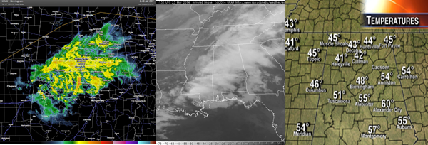
Rain developed and moved across much of the Southeast US overnight. While the patchy rain and showers were rather widespread in a wide band from Knoxville, TN, to near Lake Charles, LA, it was not a continuous rain with numerous holes in the radar coverage. Rainfall amounts so far have been rather light with a number of locations reporting less than a tenth of an inch of rain so far since midnight. Due to the spotty nature of the rain and showers, rainfall amounts for this event are likely to be somewhat light with storm totals coming in around one third to one half inch. The morning will be dreary and wet withe off and on rain and showers, but we will see the afternoon dry out as the frontal boundary responsible for the rain moves steadily east and southeast. It’s possible that we might see a few rays of sunshine by the latter part of the afternoon especially from about Pell City westward across Central and western sections of Central Alabama. And temperatures will be down from the really nice warmth we saw yesterday with todays temperatures holding steady in the 50s and perhaps nudging downward somewhat. The actual high for the day may have already been recorded with the 12:01 am temperature of 60 degrees at the Birmingham Shuttlesworth Airport.
Surface high pressure settles into the Ohio Valley on Monday, so we should be warm and coolish with highs recovering a bit into the lower 60s. The nearly zonal upper flow with a couple of weak disturbances moving through that pattern will be changing dramatically with the digging of a substantial trough of low pressure into the Southeast US on Tuesday. Moisture will be really limited with this trough, so it looks like we’ll just see some clouds, but there is a brief chance for some light rain between about midnight and 6 am Tuesday morning. Tuesday will be another one of those raw days with a stiff northwesterly wind at 15 to 25 mph and temperatures remaining steady much of the day with readings in the 50s.
Wednesday morning is expected to be the coldest morning for this coming week with the sunrise lows dipping back into the 20s. If you have any tender vegetation outside, you will want to consider taking precautions to protect it. And don’t forget those outdoor pets who will need your help to keep warm with this late Spring chill. But after this deep chill down, we should see a fairly quick warming trend into the latter part of the week. Unfortunately, as we work for the weekend rain chances will again be on the increase with showers possible Friday and Saturday. But with the strongest westerlies sitting along the northern tier of the US, we should see temperatures return to the 70s for highs with no sign of any kind of significant severe weather threat in the outlook.
Looking out into Week 2 or voodoo country, the GFS continues to present the idea of a very warm start to April with the development of a substantial ridge along the East Coast of the US. The strong ridge breaks down somewhat into early April but seems to stay just strong enough to keep the traveling weather systems well north of Alabama. At least until April 7th when the GFS develops a strong trough into the Central US that could foreshadow a fairly significant weather system for the Mississippi River Valley and eastern US. We’ll be watching.
And you can follow news and weather updates from ABC 33/40 on Twitter here. Stay in the know by following the whole gang – here’s the list…
| James Spann | Charles Daniel | Ashley Brand |
| J. B. Elliott | Bill Murray | Brian Peters |
| E-Warn (AL wx watches/warnings) |
James Spann should be back in the hot seat first thing on Monday morning with the next edition of the Weather Xtreme Video. Thanks for staying tuned to the Blog for your best source of up-to-date weather information. Enjoy the rain, stay dry, and Godspeed.
-Brian-
Category: Alabama's Weather


