Rain To The South
An all new edition of the ABC 33/40 Weather Xtreme video is available in the player on the right sidebar of the blog. You can subscribe to the Weather Xtreme video on iTunes by clicking here.
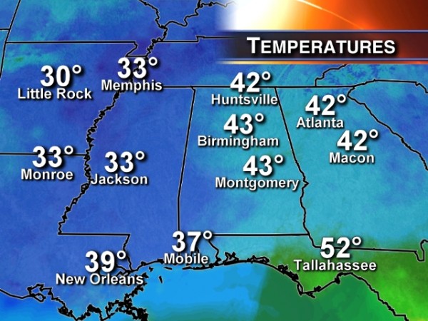
RADAR CHECK: Rain is becoming widespread over the southern half of Alabama this afternoon; the rain is generally south of a line from Demopolis to Prattville to Dadeville and on to Lafayette. It is a cold rain with temperatures in the upper 30s and low 40s over South Alabama.
Clouds cover North Alabama, and most communities are in the 40s. Interesting to note that Mobile, at 35 degrees, is 8 degrees colder than Birmingham’s 43 at 3:00p CT.
TONIGHT: The northern edge of the rain could approach I-20 tonight, and we will continue to mention a chance of some scattered light rain as far north as Tuscaloosa, Birmingham, and Anniston. High resolution model data from the NAM hints some pretty good rain could fall in a zone from Clanton to Rockford to Ashland and Ranburne tonight. Otherwise, clouds hang tough tonight with temperatures lowering into the mid 30s.
We will need to watch for potential colder pockets where temperatures try and drop to freezing. Also, cold air damming needs be monitored for potentially colder air draining into East Alabama from Georgia. But, at the moment, we don’t expect any issues with freezing rain or ice across Alabama tonight.
TOMORROW: Looks like the rain will exit the state pretty early in the day, although a touch of light rain or drizzle will be possible along and south of I-20 through mid-morning. We might see brief glimpse of the sun tomorrow afternoon, but don’t hold your breath. Clouds should stick around most of the day with a high in the mid 50s.
MORE RAIN ON THURSDAY: The next wave in the southern branch of the jet stream will bring rain to all of Alabama Thursday. The 12Z model runs are more aggressive with the wet weather, and rain amounts of around 1/2 inch look likely. I don’t think it rains all day, but it could rain at any time during the day. Otherwise, the day will be cloudy, chilly, and damp. I am not sure we can get out of the 40s with the rain falling at times.
FRIDAY AND THE WEEKEND: The good news is that our weather will be brighter and warmer just in time for the weekend. Expect a good supply of sunshine Friday and Saturday; we reach the low 60s Friday, and Saturday’s high will be very close to 70 degrees. And, Sunday is now looking mostly rain-free as the next wave stays well to the west of Alabama; Sunday should be a partly sunny day with a high in the 67 to 71 degree range.
NEXT WEEK: Models are in much better agreement, and suggest the next rain event will come on Tuesday, March 11. Doesn’t look like a severe weather threat at this point.
VOODOO LAND: The 12Z GFS shows a big rain event here around March 16, followed by a sharp change to colder weather and a chance of snow flurries March 17. See the Weather Xtreme video for the maps, graphics, and details.
STORM ALERT XTREME: Don’t forget will will offer the basic storm spotter class tomorrow evening at 6:30 at the Pelham Civic Complex. We need more trained storm spotters in Alabama, and this is your chance to help us. You won’t look at a storm the same way again. No age limits, no cost, no registration. Just come and be ready to learn. See you there!
WEATHER BRAINS: Don’t forget you can listen to our weekly 90 minute netcast anytime on the web, or on iTunes. This is the show all about weather featuring many familiar voices, including our meteorologists here at ABC 33/40. Scroll down for the show notes on the new episode we recorded last night.
CONNECT: You can find me on all of the major social networks…
Facebook
Twitter
Google Plus
Instagram
I had a great time today visiting with the 3rd graders at Vincent Elementary in Shelby County… be looking for them on the Pepsi KIDCAM today at 5:00 on ABC 33/40 News! The next Weather Xtreme video will be posted here by 7:00 a.m. tomorrow….
Category: Alabama's Weather


