Brighter, Calmer Day
An all new edition of the ABC 33/40 Weather Xtreme video is available in the player on the right sidebar of the blog. You can subscribe to the Weather Xtreme video on iTunes by clicking here.
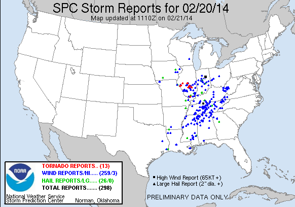
STORMS ARE GONE: Drier air is pushing into Alabama in the wake of the band of strong to severe thunderstorms last night. Most of the damage was over the Tennessee Valley of extreme North Alabama; one of the more significant damage reports was from Fort Payne around 12:30 a.m… a truck trailer was reported blown on top of an industrial building in north Fort Payne at the intersection of County Road 137 and exit 224 on I-59. Damage also reported at an apartment complex northeast of this location where the roof was blown off and 25-30 people were displaced. No injuries were reported.
There was scattered tree and power line damage down our way; Alabama Power reported 25,000 outages in the Birmingham metro as of 5:00 a.m.
At daybreak, the band of storms in Alabama was along and south of a line from Auburn to Florala, and they will exit South Alabama soon.
TODAY/TOMORROW: We will enjoy a sunny sky today and tomorrow; today’s high will be close to 60 degrees. Then tomorrow, after starting the day in the mid 30s, we warm into the mid 60s by afternoon.
SUNDAY: An impulse near the Gulf Coast will bring clouds back to Alabama. The most widespread rain Sunday will come over the southern half of the state, but the high resolution NAM model now hints that some rain is possible up into the North-Central part of the state, and we will introduce the chance of some light rain at times on Sunday up to U.S. 278 (Hamilton to Cullman to Gadsden). Don’t think the rain amounts will be that heavy up here, but parts of South Alabama could see over 1/2 inch Sunday. The high will stay in the 60s.
NEXT WEEK: The week looks mostly dry, although some patchy light rain could break out Wednesday as much colder air moves into the state. As expected, the GFS has trended colder, now suggesting highs in the 40s on Wednesday and Thursday. The low will drop down in the 20s early Thursday and Friday morning. See the Weather Xtreme video for the maps, graphics, and details.
WEATHER BRAINS: Don’t forget you can listen to our weekly 90 minute netcast anytime on the web, or on iTunes. This is the show all about weather featuring many familiar voices, including our meteorologists here at ABC 33/40.
CONNECT: You can find me on all of the major social networks…
Facebook
Twitter
Google Plus
Instagram
Busy day ahead… I have weather programs at Northside Middle School in Tuscaloosa County, and Calera Elementary in Shelby County. Look for the next Weather Xtreme video here by 4:00 or so this afternoon. Enjoy the day!
Category: Alabama's Weather


