Mild Week Ahead; Storms Thursday Night
An all new edition of the ABC 33/40 Weather Xtreme video is available in the player on the right sidebar of the blog. You can subscribe to the Weather Xtreme video on iTunes by clicking here.
MILD FEBRUARY WEEK: In contrast to the cold and snow we dealt with last week, we will enjoy spring-like warmth. The high today will be in the mid to upper 60s; clouds will slowly increase as moisture levels rise.
We will mention a chance of showers tonight with a weakening surface front pushing into the state. There is little upper support, and rain amounts should be light and spotty. Best chance of rain comes in the 10 p.m. to 4 a.m. time frame.
TOMORROW/WEDNESDAY: Tomorrow looks dry and very pleasant with a partly sunny sky; we should reach the upper 60s again. The air will be a little drier in the wake of the overnight front. Then, on Wednesday, the old front will move northward as a warm front, so clouds will increase and we can’t rule out a shower, but much of the day will still be dry. The high Wednesday will be at or just over 70 degrees.
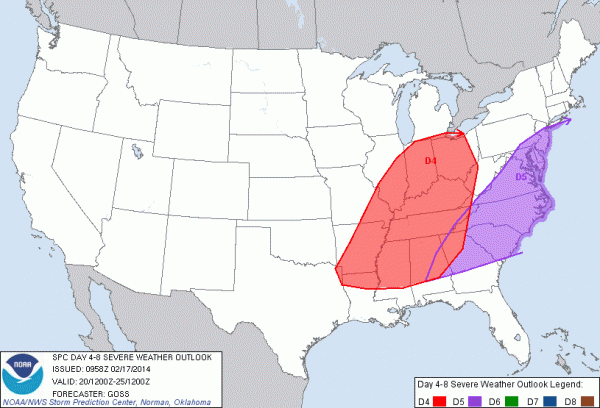
SEVERE WEATHER POTENTIAL THURSDAY NIGHT: A vigorous upper trough will spin up a surface low over the Great Lakes Thursday with a trailing cold front down into the Deep South. The day Thursday will be very mild and breezy; the GFS is printing a high of 75 degrees, within three degrees of the record high for February 20 (78 set in 1986). I can’t rule out the chance of a shower in spots during the day Thursday, but the big event comes late Thursday night into the pre-dawn hours Friday.
SPC has introduced a risk of severe weather for late Thursday night and early Friday…
With the primary surface low so far north, the main threat will come from strong, perhaps damaging straight line winds. We note the low level jet (at 850 mb, or about 5,000 feet off the ground) will be well over 50 knots over North Alabama, and it won’t take much to get some of this down to the surface with the line of storms. Could very well be enough to knock down trees and power lines.
The low level bulk shear values (surface to 925 mb) are over 40 knots, so if we have any breaks or kinks in the line of storms, an isolated tornado can’t be ruled out either.
The main threat will come from about 10:00 p.m. Thursday until 6:00 a.m. Friday. See the Weather Xtreme video for the maps, graphics, and more details.
FRIDAY/SATURDAY: The storms will exit the area early Friday, and the rest of the day will be dry with the sky becoming mostly sunny. It will be cooler with a high in the 50s Friday afternoon. Saturday looks delightful with a partly sunny and a high back in the mid 60s.
SUNDAY: The latest GFS run (06Z) shows a wave in the Gulf of Mexico that will bring rain back into Alabama Sunday with a cloudy sky and a high around 60 degrees.
Cooler air follows the wave early next week as the high will drop back into the 50s.
LONG RANGE: The GFS is advertising a pretty good cold snap around February 27, so don’t even think about putting up the jackets. We all know cold snaps are likely here into April.
WEATHER BRAINS: Don’t forget you can listen to our weekly 90 minute netcast anytime on the web, or on iTunes. This is the show all about weather featuring many familiar voices, including our meteorologists here at ABC 33/40. Bill Bunting, Operations Branch Chief, Storm Prediction Center, will be the guest on this week’s show that will be produced at 8:30 CT tonight. You can watch it on “James Spann 24/7” on cable systems around the state, or on the web here.
CONNECT: You can find me on all of the major social networks…
Facebook
Twitter
Google Plus
Instagram
I have a weather program this morning at West Point Intermediate School in Cullman County… look for the next Weather Xtreme video here by 4:00 this afternoon. Enjoy the day!
Category: Alabama's Weather


