Rain To Snow Change Imminent
Important points for the rest of today and tonight…
*Travel/driving conditions will deteriorate between now and 4 p.m. As colder air moves in from the east, and dynamic cooling brings colder air down from aloft. I would not advise travel past 4 p.m. if at all possible across North-Central Alabama.
*Rain will change to snow quickly between 2 and 4 p.m. across North and East Alabama as a strong upper trough sweeps in from the west. This will come very quickly.
*A band of heavier snow, about 40 miles wide, will set up over North and East Alabama; this band could produce some 3-5 inch snow totals. This will most likely be somewhere close to I-59. North of this heavier snow band, amounts of 1-3 inches are likely.
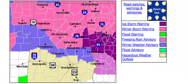
*Freezing rain will likely continue over East Alabama’s Cleburne, Randolph, and Clay counties with significant ice accumulation likely, along with potential for power outages. Clay, Tallapoosa, Chambers, and Lee counties will also see some icing.
*Snow is likely from around 4:00 p.m. until 10:00 p.m. We will watch radar trends closely; someone within the heavier snow band could get more snow than forecast if indeed we see 8 hours of this.
*The snow/freezing rain ends around midnight; temperatures will continue to fall into the low to mid 20s early tomorrow, and hazardous driving will be an issue where snow falls tonight. Roads will begin to improve late tomorrow morning as a warming trend begins.
The rain to snow scenario matches our forecast from last night nicely. A winter storm warning remains in effect for places east of a line from Hamilton to Jasper to Birmingham to Sylacauga to Roanoke. An ice storm warning remains in effect for Cleburne and Randolph counties….?
Category: Alabama's Weather


