A Little Cooler Today; Moisture Returns Friday
An all new edition of the ABC 33/40 Weather Xtreme video is available in the player on the right sidebar of the blog. You can subscribe to the Weather Xtreme video on iTunes by clicking here.
COLD MORNING: Seeing some mid 20s early this morning… 26 degrees at daybreak at Haleyville and Black Creek; 27 at Cullman, Russellville, and Valley Head. The sky is clear, and the wind is light.
Today will be a little cooler thanks to an Alberta Clipper that passed north of the state yesterday; our high today will drop back into the mid 50s despite a sunny sky.
The sky will stay sunny tomorrow with a high in the low 60s.
FRIDAY: Moist air returns to the state, and a few scattered showers could break out Friday afternoon. The sky will feature more clouds than sun, and the high will be in the mid to upper 60s as the warming trend continues.
WARM WEEKEND: The GFS is printing a high of 74 degrees for Birmingham Saturday; if that verifies that will break the old record of 73 for December 21 set in 1923. A few showers are possible during the day, but the most widespread rain should be north of the state, north of a warm front that will be over southern Tennessee. The sun might even break out at times Saturday with a good south wind of 10-20 mph.
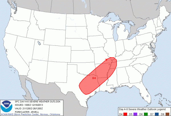
TO THE WEST: SPC has defined a risk of severe weather Saturday from Texas to the western part of Tennessee and Kentucky.
A surface low will form over Texas Saturday, and in the broad warm sector severe storms are possible through this zone during the afternoon and into Saturday night. If you are traveling west of Alabama, be aware of the threat.
STORMY SUNDAY: The main action over the weekend for our state will come Sunday. Models are in a little better agreement, and I believe the main 12 hour window for strong to severe storms will come from 1:00 a.m. until 1:00 p.m. Sunday.
The surface low will move from Arkansas up toward Ohio early Sunday morning, with a trailing line of storms moving through Alabama. The guys at SPC (and I agree) believe the main mode here will be linear, meaning the primary threat will come from strong, perhaps damaging straight line winds. SPC has opted not to include any severe weather risk on Sunday for now with some uncertainty remaining.
We note the low level jet (winds around 5,000 feet off the ground) is projected by the GFS model to be over 70 knots over North Alabama, and it won’t take much to get these winds down to the surface. The line of storms Sunday morning will certainly have potential to knock down trees and power lines, so you will need to pay attention to severe thunderstorm warnings if they are issued.
We do note the bulk shear between the surface and 925 mb is around 40 knots, so there could be a tornado or two embedded in the line of storms.
Hopefully the early morning timing will help to mitigate the severe weather threat to some degree (the air tends to be more stable early in the morning), but there is certainly plenty of dynamic support for some severe weather, if the GFS model is correct.
Be sure your church can receive severe weather warnings since the event will come Sunday morning. Take some time to watch the Weather Xtreme video for the maps, graphics, and details.
The storms will sweep out of the state late Sunday.
CHRISTMAS WEEK: Colder and drier air rolls into Alabama Monday as the sky becomes mostly sunny. We are still looking at cool and dry weather Tuesday and Christmas Day, with highs in the 50s and lows around freezing… this is right at seasonal values for late December in Alabama. No snow, no rain. Very nice weather.
TOYS FOR TOTS: Our annual 26 hour drive continues today at Southern Legacy BBQ on Highway 150 in Hoover; please consider bringing a new, unwrapped toy by today. I will be there on ABC 33/40 News at 4, 5, and 6:00 this evening.
WEATHER BRAINS: Don’t forget you can listen to our weekly 90 minute netcast anytime on the web, or on iTunes. This is the show all about weather featuring many familiar voices, including our meteorologists here at ABC 33/40.
CONNECT: You can find me on all of the major social networks…
Facebook
Twitter
Google Plus
Instagram
Look for the next Weather Xtreme video here by 4:00 this afternoon. Enjoy the day…
Category: Alabama's Weather


