Dry Week Ahead; Turning Warmer
An all new edition of the ABC 33/40 Weather Xtreme video is available in the player on the right sidebar of the blog. You can subscribe to the Weather Xtreme video on iTunes by clicking here.
SEVERE CLEAR: Following a Sunday with stubborn clouds and a high in the 30s over North Alabama, today will be brighter and warmer. With sunshine in full supply, we project a high in the mid 50s this afternoon.
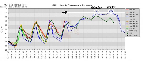
NICE WARM-UP THIS WEEK: We will enjoy a day to day warming trend this week, and by Friday our high will be very close to 70 degrees.
There is no risk of rain through Thursday with sunny days and fair nights. Moisture will increase on Friday, however, and a few showers could break out in the warm air advection pattern. Nothing really organized, most likely.
STORMY WEEKEND: This is the fall tornado season in Alabama, so having the risk of strong to severe storms in November or December is not unusual, and is to be expected. And, unfortunately it looks like there will be some risk of severe weather in Alabama before the weekend is over, but there is no way of resolving details now with inconsistent model output.
We will warm into the low to mid 70s Saturday and Sunday, and showers are possible Saturday into Saturday night in the moist air. Rain Saturday will not be continuous, and you might even see a peek or two of sunshine.
The window for strong storms will come Sunday or Sunday night. The 06Z GFS shows a sub-1000 mb surface low near Little Rock at midday Sunday, with Alabama in the warm sector as we rise into the mid 70s. A strong low level jet (over 60 knots at 850 mb) and very significant low level bulk shear (1000-925 mb bulk shear of over 40 knots) could suggest a significant severe weather threat.
However, the ECMWF gives a completely different look with the primary surface low Sunday near Buffalo, NY with only marginal severe weather parameters here.
BOTTOM LINE: It is too early to know the magnitude of the severe weather threat in Alabama late this weekend, if there is one at all. The guys at the Storm Prediction Center are the best at the world in identifying severe weather potential, and they do not have any risk defined at this point due to the uncertainty. You might hear of some fear mongering from non meteorologists on blogs or message boards, but let that go in one ear and out the other. We will have better clarity at mid-week. Stay tuned.
See the Weather Xtreme video for a more details on the weekend weather situation with maps and graphics.
CHRISTMAS WEEK: We turn colder Monday of next week in the wake of the storms with a high in the 45-50 degree range with a chilly north wind. The weather looks cool and dry for Tuesday and Christmas Day, with highs in the 50s and lows in the 30s, right at seasonal averages for late December in Alabama. If you are looking for a White Christmas, you better drive far to the north of here.
WEATHER BRAINS: Don’t forget you can listen to our weekly 90 minute netcast anytime on the web, or on iTunes. This is the show all about weather featuring many familiar voices, including our meteorologists here at ABC 33/40. We will produce this week’s show at 8:30p CT… you can watch it live on “James Spann 24/7” on cable systems around the state, or on the web here.
CONNECT: You can find me on all of the major social networks…
Facebook
Twitter
Google Plus
Instagram
Look for the next Weather Xtreme video here by 4:00 or so this afternoon. Enjoy the day!
Category: Alabama's Weather


