An Early Evening Update on Alabama’s Weather
LATE UPDATE 7:11 PM
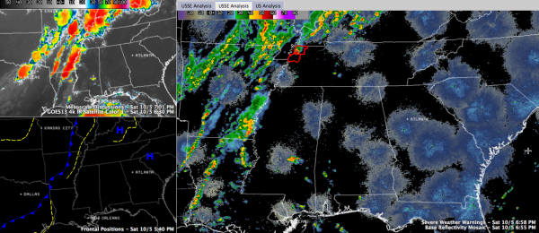
The storm containing the possible tornado is now 13 miles southwest of Union City. Law Enforcement reported a tornado touchdown in Elbridge at 6:52 p.m.
ORIGINAL POST
As expected, showers started to form over Northeast Mississippi and extreme western Alabama at mid-afternoon. They developed in an area of convergence between the southeasterly flow around high pressure to our east and the approaching strong trough and front to our west. Aided by the heating of the day, they went downhill as we approached sunset.
Meanwhile, more widespread and stronger storms have been occurring over Kentucky, western Tennessee and Arkansas. These storms have prompted a few warnings, including a couple of tornado warnings.
There has been a tornado warning on a cell north of Dyersburg. The storm shows signs of rotation and has a wall cloud associated with it. It is heading in the direction of Union City, Tennessee.
The showers and storms will weaken as they move deeper into western Tennessee and northern Mississippi overnight, but they won’t fall completely apart.
Additional showers will start to form over North and Central Alabama around sunrise. They will begin to increase in coverage and intensity as the morning rolls along and heating starts to add energy to the atmosphere. The development and intensity will be enhanced by the strong front that will be knifing into the area as well. Showers and storms will be likely all across Central and North Alabama through the afternoon, with the main line of storms moving into West Alabama during the late afternoon and slowly across the state during the evening hours. Most of the activity should be into Georgia by midnight.
This will set the stage for a nice run of typical October weather starting Monday and lasting much of the week ahead.
Be back in a moment with an updated look at Karen, which remains a minimal tropical storm sitting stationary off the Louisiana coast.
Category: Alabama's Weather, Severe Weather


