Oops Karen, Your Center is Showing!
Lucky for us, Tropical Storm Karen continues to be impacted by moderate wind shear this afternoon over the Gulf of Mexico. The stronger winds are blowing thunderstorms off to the northeast as soon as they get some height.
The storm looks like a little steam engine, trying to huff and puff its way to being stronger, but meeting stiff resistance from the winds.
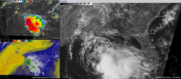
This set of images shows the storm in three formats. You can click the image to enlarge it.
On the larger visible satellite image on the right panel, you can see the center clearly exposed.
On the top left panel, the color enhanced infrared image shows the thunderstorms that have already blown off to the northeast and a new small bright red burst of convection signalling new storm development.
On the lower left panel, the water vapor imagery clearly shows the very dry air to the west of the storm (shown in bright yellow). The storm is its own worst enemy as the circulation tries to ramp up, it pulls in the dry air, stifling convection and keeping the storm from growing.
So you can see that Karen is battling a hostile environment. Good thing, because it is over some warm water, running 30C. That is like Wheaties for a tropical cyclone. It should continue to run over 29C water until Saturday morning when it should start to encounter 28C water. That still is enough to support strengthening. We expect some strengthening as the wind shear should relax late tonight and Saturday morning.
Category: Tropical


