Hurricane Ingrid Gaining Strength
This afternoon, as expected, Ingrid became our second hurricane of the 2013 season. Ingrid is in a favorable environment for intensification and is expected to gain strength before it makes landfall along the eastern Mexican Coast. Ingrid will not affect Alabama or the northern Gulf Coast. A look at the satellite shows that the clouds tops are cooling, which is showing the storm is intensifying. The center of circulation is certainly getting better organized and I would not be surprised to see an eye develop before landfall.

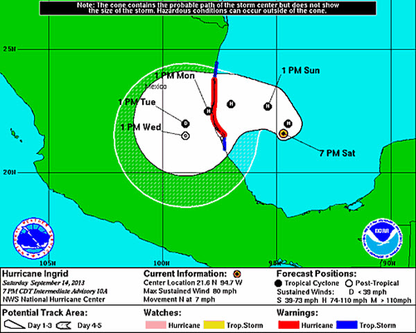
SUMMARY OF 700 PM CDT…0000 UTC…INFORMATION
———————————————-
LOCATION…21.6N 94.7W
ABOUT 180 MI…290 KM ENE OF TUXPAN MEXICO
ABOUT 250 MI…400 KM SE OF LA PESCA MEXICO
MAXIMUM SUSTAINED WINDS…80 MPH…130 KM/H
PRESENT MOVEMENT…N OR 350 DEGREES AT 7 MPH…11 KM/H
MINIMUM CENTRAL PRESSURE…983 MB…29.03 INCHES
The official track from the NHC, has the storm continuing a northward movement before it takes a turn to the west and makes landfall in Mexico on Monday.
Category: Tropical
About the Author (Author Profile)
Macon, Georgia Television Chief Meteorologist, Birmingham native, and long time Contributor on AlabamaWX. Stormchaser. I did not choose Weather, it chose Me. College Football Fanatic. @Ryan_StinnetSubscribe
If you enjoyed this article, subscribe to receive more just like it.


