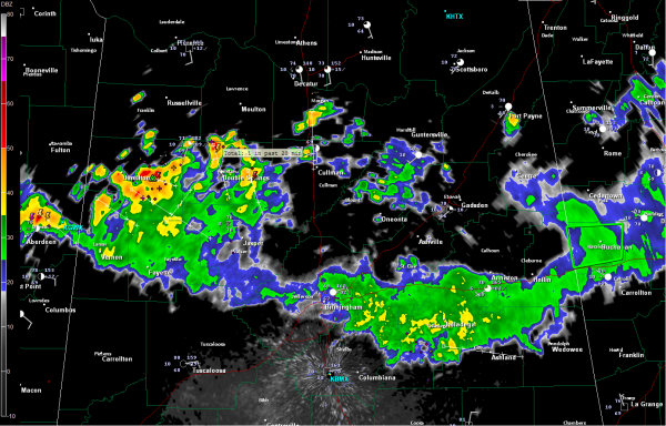
Heaviest Rain over Northwest Alabama
The heaviest rain across the northern half of Alabama is over northwestern sections of the state, over Marion, Winston and northern Lamar Counties. Lots of lightning involved from Haleyville to Winfield to Sulligent. This activity will push into Fayette, Walker and southwestern Cullman Counties shortly.
East of this, some showers and isolated thunder are over Morgan, northern Cullman and northern Blount Counties. This activity will push into part of western Etowah and St. Clair Counties over the next hour.
In the Birmingham Metro, the showers were weakening, with the back edge now coming through Gardendale and Pinson. The rain still extends well down Us-280 but will be coming to an end from the northwest, giving us a break. The showers over Winston and northern Cullman may affect parts of the metro around 12-12:30, but the heaviest rain should stay over western sections of Jefferson County, perhaps only brushing downtown for the Barons final regular season game before the Playoffs.
The Barons are just 7.568 fans from reaching an amazing 400,000 in attendance in this inaugural season at Regions Field! Be there to help them set the mark.
After these showers push southeast, the afternoon looks dry. Can’t rule out a stray shower, but most afternoon activities could be dry.
More showers and storms will form overnight tonight, but drier air is in store behind a cold front that will arrive early tomorrow.
Category: Alabama's Weather


