Heavy Storms Over Birmingham Again
MORE REPORTS 5:47 house on Briarcliff Rd on a possible house fire. Residence reporting lightning struck house & house filling with smoke.
Heavy flooding near Mountain Brook Village at Cahaba Road and Lane Park Road. One car is stalled in standing water.
LATE REPORT 5:42
John Talbot reports Mtn Brook pd dispatch reporting they have a tree on top of a car at Montevallo Rd & Overhill Rd. NO injuries, “HEAVY standing water” on Montevallo Rd. Also same officer saying that this a very large tree down & is blocking the rd.
ORIGINAL POST
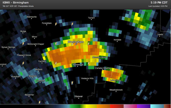
A heavy thunderstorm covers the southern half of the Birmingham Metro right now.
Here is a closeup of the radar:
Areas from downtown back to Fairfield and Midfield southeast into Homewood and Mountain Brook are seeing the heaviest rain. There is plenty of dangerous lightning as well. The lightning is increasing.
1.52 inches of rain at the Birmingham Airport so far, with more on the way.
Elsewhere, even stronger storms extend from Winston County between Double Springs and Addison through Walker County near Jasper and into extreme northwestern Jefferson County.
More are over northwestern Alabama and there is a strong storm northeast of Tuscaloosa.
Otherwise, showers/storms are scattered across the rest of North Central Alabama.
There are also some storms southwest of Alexander City in South Central Alabama.
Category: Alabama's Weather


