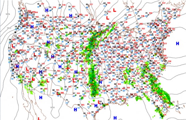
National Highlights
An upper low between Kansas City and Little Rock is bringing showers and storms to the Central and Southern Plains this morning, where they can use the rain. The Dallas/Fort Worth Metroplex is receiving welcome showers this morning, although the amounts are generally light. After fice straight days of 100+ readings at DFW, today’s high is forecast to be only 83F in the Big D. Monday’s high will be even cooler, at 82F! Maybe Kevin Selle will be less grumpy on WeatherBrains tomorrow night!
But it is going to take a lot of rain to ease the drought for places from western Nebraska and Kansas across New Mexico, western Oklahoma and much of the Lone Star State.
Record highs on Saturday included 105F at Austin/Camp Mabry (tied) and 104F at Austin-Bergstrom. The 103F at College Station tied the record for the date. It was 101F at Houston Hobby and 102 at San Antonio, both records. On the nicer side of the ledger, it was 60F yesterday morning at Vicksburg MS and 57F at Jackson TN. Both of those readings were the coolest ever observed on July 13th. It was positively bracng in Eureka, CA, where the morning low fell to 47F, also a record. Ahhhh!
Strong storms rumbled through the Dakotas overnight, where a severe thunderstorm watch was in effect through much of the predawn. Winds gusted to 64 mph at Mobridge, SD. There were a few reports of 60 mph winds.
A tornado was reported Saturday morning near Beaufort SC. A waterspout briefly became a tornado as it made landfall on Hunters Island. It dissipated before doing any damage.
There was wind damage reported in Northwest Alabama Saturday evening, with trees down and power outages in the Green Hill community in Lauderdale County from those nighttime storms there.
Hotter weather will be building over much of the eastern United States this week as the Bermuda High sets up shop to the west of its normal location. Excessive heat warnings and watches are already in effect around Philadelphia and those will become common in the week ahead as the heat wave should remain in control until the weekend. Highs in the middle 90s with dewpoints around 70F can allow for heat exhaustion problems in people, especially in urban areas that aren’t as prepared.
The tropics are quiet and look like they may remain so through the end of the month, with a negative Madden-Julian Oscillation phase suppressing convection and strong wind shear continuing over the tropical Atlantic.
Category: Headlines


