Heavy Clouds, A Little Rain
Clouds are thick across much of Alabama on this Sunday morning. The only exception is the coastal counties of Mobile and Baldwin, up into Washington County.
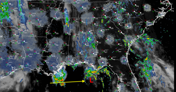
Gulf and Atlantic moisture is flowing into Atlanta in the flow between a big surface high east of Washington DC and a weak surface low in the Gulf of Mexico. That low in the Gulf was rotating just south of Panama City. It should move onshore in the next few hours. It brought heavy rain to the coast between Fort Walton and Apalachicola earlier this morning. I saved you a neat picture of the radar composite clearly showing the low center from early this morning.
Another center of low pressure was south of New Orleans as well. Neither of the low pressure systems will be tropical players, thank goodness.
A few light to moderate showers were in the plume of moisture wrapping around the Gulf lows and up into Alabama. They are mainly along the US-280 and US-78/82 corridors. Showers are generally light over Lamar, Marion, Fayette, Winston and Walker Counties as well as northern Tuscaloosa County. Moderate showers were affecting northeastern Jefferson, southern Blount and western St. Clair Counties. The heaviest precipitation was near Branchville, approaching Springville.
It won’t take much for showers and storms to form today. In fact, temperatures of about 76F are all it will, and most locations are already there. The mesoscale models predict that we will see good coverage of showers and storms in this same moisture plume, that will shift westward slowly today with that big upper trough.
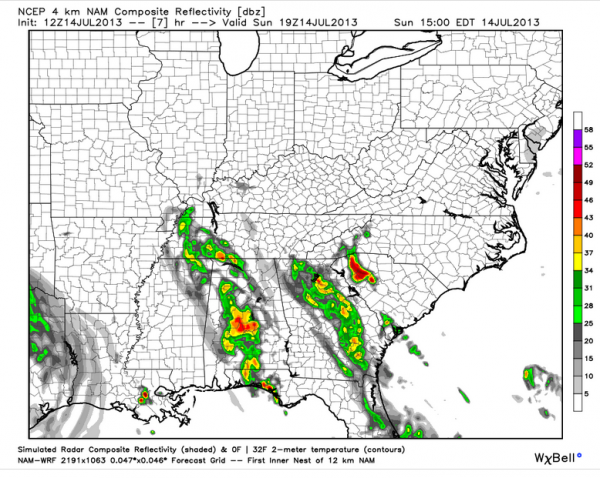
Here is the NAM simulated radar for 2 p.m. CDT:

This would indicate areas from Cullman County down through western St. Clair into Tallapoosa Counties will likely see the best rain chances today, with the heaviest rain west of a line from Jasper to Birmingham to Wetumpka. We will be watching the radar.
Some heavy rain will develop, and thunderstorms will carry lots of dangerous lightning, so be careful.
Category: Alabama's Weather


